National Register of Historic Places listings in Horry County, South Carolina

This is a list of the National Register of Historic Places listings in Horry County, South Carolina.
This is intended to be a complete list of the properties and districts on the National Register of Historic Places in Horry County, South Carolina, United States. The locations of National Register properties and districts for which the latitude and longitude coordinates are included below, may be seen in a map.[1]
There are 35 properties and districts listed on the National Register in the county, and 2 former listings.
This National Park Service list is complete through NPS recent listings posted June 14, 2024.[2]
Map all coordinates using OpenStreetMap
Download coordinates as:
- KML
- GPX (all coordinates)
- GPX (primary coordinates)
- GPX (secondary coordinates)
Current listings
| [3] | Name on the Register[4] | Image | Date listed[5] | Location | City or town | Description |
|---|---|---|---|---|---|---|
| 1 | H.W. Ambrose House |  | August 5, 1986 (#86002219) | 1503 Elm Street 33°50′47″N 79°03′32″W / 33.8464°N 79.0589°W / 33.8464; -79.0589 (H.W. Ambrose House) | Conway | |
| 2 | Atlantic Coast Line Railroad Depot |  | May 18, 1995 (#86003839) | Northern side of U.S. Route 701 33°50′17″N 79°02′36″W / 33.8381°N 79.0433°W / 33.8381; -79.0433 (Atlantic Coast Line Railroad Depot) | Conway | |
| 3 | Beaty-Little House |  | August 5, 1986 (#86002220) | 507 Main Street 33°50′18″N 79°02′56″W / 33.8383°N 79.0489°W / 33.8383; -79.0489 (Beaty-Little House) | Conway | |
| 4 | Beaty-Spivey House | 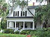 | August 5, 1986 (#86002223) | 428 Kingston Street 33°50′15″N 79°02′47″W / 33.8375°N 79.0464°W / 33.8375; -79.0464 (Beaty-Spivey House) | Conway | |
| 5 | Buck's Upper Mill Farm | 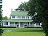 | March 25, 1982 (#82003868) | North of Bucksville 33°44′19″N 79°03′48″W / 33.7386°N 79.0633°W / 33.7386; -79.0633 (Buck's Upper Mill Farm) | Bucksville | |
| 6 | Burroughs School |  | August 2, 1984 (#84002047) | 801 Main Street 33°50′30″N 79°03′07″W / 33.8417°N 79.0519°W / 33.8417; -79.0519 (Burroughs School) | Conway | |
| 7 | Arthur M. Burroughs House | 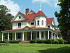 | August 5, 1986 (#86002224) | 500 Lakeside Drive 33°50′27″N 79°02′50″W / 33.8408°N 79.0472°W / 33.8408; -79.0472 (Arthur M. Burroughs House) | Conway | |
| 8 | Conway Downtown Historic District | 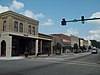 | August 19, 1994 (#94000815) | Roughly bounded by 4th Avenue, Kingston Street, 3rd Avenue, and Laurel Street 33°50′10″N 79°02′51″W / 33.8361°N 79.0475°W / 33.8361; -79.0475 (Conway Downtown Historic District) | Conway | Boundary Increase (listed 3/31/2010): Portions of Main St, 3rd Ave, 4th Ave, Laurel St. |
| 9 | Conway Methodist Church, 1898 and 1910 Sanctuaries | 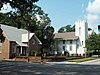 | August 5, 1986 (#86002225) | 5th Avenue 33°50′12″N 79°02′53″W / 33.8367°N 79.0481°W / 33.8367; -79.0481 (Conway Methodist Church, 1898 and 1910 Sanctuaries) | Conway | |
| 10 | Conway Post Office |  | September 2, 2009 (#08000758) | 428 Main Street 33°50′15″N 79°02′51″W / 33.8374°N 79.0474°W / 33.8374; -79.0474 (Conway Post Office) | Conway | |
| 11 | Conway Residential Historic District | 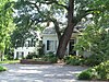 | April 7, 2010 (#10000166) | Main St. on the east, Fifth Ave to the south; Beaty and Burroughs Sts. to the west, and Ninth and Tenth Aves. to the north 33°50′22″N 79°03′07″W / 33.8394°N 79.0519°W / 33.8394; -79.0519 (Conway Residential Historic District) | Conway | |
| 12 | John P. Derham House |  | October 4, 2005 (#05001154) | 1076 Green Sea Road 34°07′26″N 78°58′34″W / 34.1239°N 78.9761°W / 34.1239; -78.9761 (John P. Derham House) | Green Sea | |
| 13 | Galivants Ferry Historic District |  | March 29, 2001 (#01000321) | Junction of U.S. Route 501, Pee Dee Road, and Galivants Ferry Road 34°03′00″N 79°14′42″W / 34.05°N 79.245°W / 34.05; -79.245 (Galivants Ferry Historic District) | Galivants Ferry | |
| 14 | Hebron Church | 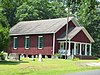 | May 16, 1977 (#77001227) | 10 miles (16 km) south of Conway off of U.S. Route 701 33°42′57″N 79°04′03″W / 33.7158°N 79.0675°W / 33.7158; -79.0675 (Hebron Church) | Bucksville | |
| 15 | J.W. Holliday Jr. House | 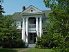 | August 5, 1986 (#86002227) | 701 Laurel Street 33°50′22″N 79°03′04″W / 33.8394°N 79.0511°W / 33.8394; -79.0511 (J.W. Holliday Jr. House) | Conway | |
| 16 | Horry County Courthouse |  | May 27, 2022 (#100007748) | 1201 3rd Ave. 33°50′01″N 79°02′55″W / 33.8336°N 79.0487°W / 33.8336; -79.0487 (Horry County Courthouse) | Conway | |
| 17 | Kingston Presbyterian Church |  | September 28, 2009 (#08000759) | 800 3rd Avenue 33°50′10″N 79°02′43″W / 33.8361°N 79.0453°W / 33.8361; -79.0453 (Kingston Presbyterian Church) | Conway | |
| 18 | Kingston Presbyterian Church Cemetery | 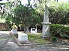 | August 5, 1986 (#86002229) | 800 3rd Avenue 33°50′10″N 79°02′43″W / 33.8361°N 79.0453°W / 33.8361; -79.0453 (Kingston Presbyterian Church Cemetery) | Conway | |
| 19 | Myrtle Beach Atlantic Coast Line Railroad Station |  | July 22, 2002 (#96001212) | Junction of Oak Street and Broadway between Jackson Street and 8th Avenue 33°41′41″N 78°53′08″W / 33.6947°N 78.8856°W / 33.6947; -78.8856 (Myrtle Beach Atlantic Coast Line Railroad Station) | Myrtle Beach | |
| 20 | Myrtle Beach Downtown Historic District | Upload image | October 18, 2019 (#100004533) | Portions of Main St., 8th Ave. N., 9th Ave. N., N. Kings Hwy., Broadway St., N. Oak St. 33°41′36″N 78°53′00″W / 33.6933°N 78.8834°W / 33.6933; -78.8834 (Myrtle Beach Downtown Historic District) | Myrtle Beach | |
| 21 | Myrtle Heights-Oak Park Historic District |  | October 28, 1998 (#96001217) | Roughly N. Ocean Boulevard between 32nd Avenue, N. and 46th Avenue, N. 33°42′52″N 78°51′14″W / 33.7144°N 78.8539°W / 33.7144; -78.8539 (Myrtle Heights-Oak Park Historic District) | Myrtle Beach | |
| 22 | Noel Court and Apartments | Upload image | January 7, 2021 (#100005988) | 312 6th Ave. North 33°40′12″N 78°53′03″W / 33.6700°N 78.8843°W / 33.6700; -78.8843 (Noel Court and Apartments) | Myrtle Beach | |
| 23 | Ocean Forest Country Club |  | November 7, 1996 (#96001219) | 5609 Woodside Drive 33°43′47″N 78°50′36″W / 33.729722°N 78.843333°W / 33.729722; -78.843333 (Ocean Forest Country Club) | Myrtle Beach | |
| 24 | Old Horry County Courthouse | 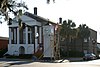 | April 7, 1971 (#71000785) | Main Street 33°50′06″N 79°02′45″W / 33.835°N 79.045833°W / 33.835; -79.045833 (Old Horry County Courthouse) | Conway | |
| 25 | Pleasant Inn |  | November 7, 1996 (#96001220) | 200 Broadway 33°41′16″N 78°53′39″W / 33.687778°N 78.894167°W / 33.687778; -78.894167 (Pleasant Inn) | Myrtle Beach | |
| 26 | C.P. Quattlebaum House | 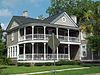 | August 5, 1986 (#86002233) | 219 Kingston Street 33°50′06″N 79°02′42″W / 33.835°N 79.045°W / 33.835; -79.045 (C.P. Quattlebaum House) | Conway | |
| 27 | C.P. Quattlebaum Office | 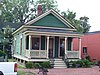 | August 5, 1986 (#86002235) | 903 3rd Avenue 33°50′07″N 79°02′44″W / 33.835278°N 79.045556°W / 33.835278; -79.045556 (C.P. Quattlebaum Office) | Conway | |
| 28 | Paul Quattlebaum House |  | August 5, 1986 (#86002231) | 225 Kingston Street 33°50′06″N 79°02′43″W / 33.835°N 79.045278°W / 33.835; -79.045278 (Paul Quattlebaum House) | Conway | |
| 29 | Socastee Historic District | 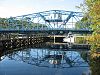 | May 22, 2002 (#02000558) | South Carolina Highway 544, .5 miles (0.80 km) north of the Intracoastal Waterway 33°59′11″N 78°59′57″W / 33.986389°N 78.999167°W / 33.986389; -78.999167 (Socastee Historic District) | Socastee | |
| 30 | Sun Fun Motel | Upload image | March 12, 2020 (#100005046) | 2305 Withers Dr. 33°42′12″N 78°52′08″W / 33.7032°N 78.8688°W / 33.7032; -78.8688 (Sun Fun Motel) | Myrtle Beach | |
| 31 | Tawana Motel | Upload image | May 13, 2019 (#100003918) | 7501 N. Ocean Blvd. 33°44′38″N 78°49′01″W / 33.7438°N 78.8169°W / 33.7438; -78.8169 (Tawana Motel) | Myrtle Beach | |
| 32 | Waccamaw River Memorial Bridge |  | August 26, 1994 (#94000994) | Main Street (U.S. Route 501 Business) over the Waccamaw River 33°49′59″N 79°02′39″W / 33.833056°N 79.044167°W / 33.833056; -79.044167 (Waccamaw River Memorial Bridge) | Conway | |
| 33 | Waccamaw River Warehouse Historic District |  | August 5, 1986 (#86002269) | Roughly Main Street between the Waccamaw River and Laurel Street 33°50′00″N 79°02′42″W / 33.833333°N 79.045°W / 33.833333; -79.045 (Waccamaw River Warehouse Historic District) | Conway | |
| 34 | Waikiki Village Motel |  | June 12, 2017 (#100001076) | 1500 S. Ocean Blvd. 33°40′26″N 78°54′04″W / 33.673798°N 78.901024°W / 33.673798; -78.901024 (Waikiki Village Motel) | Myrtle Beach | |
| 35 | W. H. Winborne House | 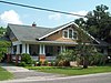 | August 5, 1986 (#86002268) | 1300 6th Avenue 33°50′11″N 79°03′07″W / 33.836389°N 79.051944°W / 33.836389; -79.051944 (W. H. Winborne House) | Conway |
Former listing
| [3] | Name on the Register | Image | Date listed | Date removed | Location | City or town | Description |
|---|---|---|---|---|---|---|---|
| 1 | Chesterfield Inn | 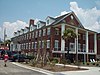 | November 7, 1996 (#96001218) | October 23, 2013 | 700 N. Ocean Boulevard 33°41′23″N 78°52′54″W / 33.689722°N 78.881667°W / 33.689722; -78.881667 (Chesterfield Inn) | Myrtle Beach | Demolished on August 22, 2012.[6][7] |
| 2 | Rainbow Court |  | November 7, 1996 (#96001221) | February 27, 2020 | 405 Flagg Street 33°41′09″N 78°53′12″W / 33.685833°N 78.886667°W / 33.685833; -78.886667 (Rainbow Court) | Myrtle Beach |
See also
Wikimedia Commons has media related to National Register of Historic Places in Horry County, South Carolina.
- List of National Historic Landmarks in South Carolina
- National Register of Historic Places listings in South Carolina
References
- ^ The latitude and longitude information provided in this table was derived originally from the National Register Information System, which has been found to be fairly accurate for about 99% of listings. Some locations in this table may have been corrected to current GPS standards.
- ^ National Park Service, United States Department of the Interior, "National Register of Historic Places: Weekly List Actions", retrieved June 14, 2024.
- ^ a b Numbers represent an alphabetical ordering by significant words. Various colorings, defined here, differentiate National Historic Landmarks and historic districts from other NRHP buildings, structures, sites or objects.
- ^ "National Register Information System". National Register of Historic Places. National Park Service. March 13, 2009.
- ^ The eight-digit number below each date is the number assigned to each location in the National Register Information System database, which can be viewed by clicking the number.
- ^ "Old Myrtle Beach inn torn down". The Times and Democrat. August 24, 2012. p. A4. Retrieved August 23, 2022 – via Newspapers.com.
- ^ http://www.heraldonline.com/2012/08/23/4208078/historic-inn-in-myrtle-beach-demolished.html[permanent dead link]
- v
- t
- e

by county
- Abbeville
- Aiken
- Allendale
- Anderson
- Bamberg
- Barnwell
- Beaufort
- Berkeley
- Calhoun
- Charleston
- Cherokee
- Chester
- Chesterfield
- Clarendon
- Colleton
- Darlington
- Dillon
- Dorchester
- Edgefield
- Fairfield
- Florence
- Georgetown
- Greenville
- Greenwood
- Hampton
- Horry
- Jasper
- Kershaw
- Lancaster
- Laurens
- Lee
- Lexington
- Marion
- Marlboro
- McCormick
- Newberry
- Oconee
- Orangeburg
- Pickens
- Richland
- Saluda
- Spartanburg
- Sumter
- Union
- Williamsburg
- York


