National Register of Historic Places listings in Allendale County, South Carolina

This is a list of the National Register of Historic Places listings in Allendale County, South Carolina.
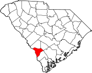
This is intended to be a complete list of the properties and districts on the National Register of Historic Places in Allendale County, South Carolina, United States. The locations of National Register properties and districts for which the latitude and longitude coordinates are included below, may be seen in a map.[1]
There are 14 properties and districts listed on the National Register in the county.
This National Park Service list is complete through NPS recent listings posted June 14, 2024.[2]
Map all coordinates using OpenStreetMap
Download coordinates as:
- KML
- GPX (all coordinates)
- GPX (primary coordinates)
- GPX (secondary coordinates)
Current listings
| [3] | Name on the Register[4] | Image | Date listed[5] | Location | City or town | Description |
|---|---|---|---|---|---|---|
| 1 | Allendale Chert Quarries Archeological District | Upload image | September 28, 1985 (#85002699) | Address Restricted | Martin | |
| 2 | Allendale County Courthouse | 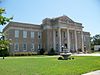 | August 1, 2007 (#06000580) | 292 Barnwell Highway 33°00′46″N 81°18′22″W / 33.0128°N 81.3061°W / 33.0128; -81.3061 (Allendale County Courthouse) | Allendale | |
| 3 | Allendale Training School | Upload image | June 10, 2022 (#100007773) | 4561 Allendale-Fairfax Hwy. 33°00′03″N 81°18′00″W / 33.0008°N 81.2999°W / 33.0008; -81.2999 (Allendale Training School) | Allendale | Equalization Schools in South Carolina, 1951-1960 MPS |
| 4 | Antioch Christian Church |  | December 12, 1977 (#77001212) | Southwest of Allendale on South Carolina Highway 3 32°56′52″N 81°24′54″W / 32.94778°N 81.41493°W / 32.94778; -81.41493 (Antioch Christian Church) | Allendale | |
| 5 | Colding-Walker House |  | April 30, 1998 (#98000415) | South Carolina Highway 52 33°02′30″N 81°21′56″W / 33.04164°N 81.36545°W / 33.04164; -81.36545 (Colding-Walker House) | Appleton | |
| 6 | Erwin House |  | May 7, 1976 (#76001687) | Southwest of Allendale off U.S. Route 301 32°57′25″N 81°24′56″W / 32.95701°N 81.41567°W / 32.95701; -81.41567 (Erwin House) | Allendale | |
| 7 | Fennell Hill | Upload image | November 19, 1974 (#74001820) | Address Restricted | Peeples | |
| 8 | Gravel Hill Plantation |  | May 28, 1976 (#76001688) | 3954 Augusta Stage Coach Road, Garnett, South Carolina 32°58′04″N 81°23′18″W / 32.967778°N 81.388333°W / 32.967778; -81.388333 (Gravel Hill Plantation) | Allendale | |
| 9 | Lawton Mounds | Upload image | June 19, 1972 (#72001185) | Address Restricted | Johnson's Landing | |
| 10 | Red Bluff Flint Quarries | Upload image | June 22, 1972 (#72001184) | Address Restricted | Allendale | |
| 11 | Roselawn | 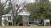 | May 28, 1976 (#76001689) | 3 miles southwest of Allendale on South Carolina Highway 47 32°58′58″N 81°20′51″W / 32.982778°N 81.3475°W / 32.982778; -81.3475 (Roselawn) | Allendale | |
| 12 | Smyrna Baptist Church |  | May 28, 1976 (#76001691) | South of Allendale on South Carolina Highway 22 32°56′11″N 81°21′07″W / 32.93652°N 81.35181°W / 32.93652; -81.35181 (Smyrna Baptist Church) | Allendale | |
| 13 | Williams House | Upload image | February 17, 1999 (#99000104) | U.S. Route 321, near Ulmer 33°05′06″N 81°12′25″W / 33.084913°N 81.207035°W / 33.084913; -81.207035 (Williams House) | Ulmer | There is a major error in the NRHP form coordinates. |
| 14 | Virginia Durant Young House |  | August 8, 1983 (#83002183) | U.S. Route 278 32°57′35″N 81°14′20″W / 32.95973°N 81.23875°W / 32.95973; -81.23875 (Virginia Durant Young House) | Fairfax | Now houses the Fairfax Public Library |
See also
Wikimedia Commons has media related to National Register of Historic Places in Allendale County, South Carolina.
- List of National Historic Landmarks in South Carolina
- National Register of Historic Places listings in South Carolina
References
- ^ The latitude and longitude information provided in this table was derived originally from the National Register Information System, which has been found to be fairly accurate for about 99% of listings. Some locations in this table may have been corrected to current GPS standards.
- ^ National Park Service, United States Department of the Interior, "National Register of Historic Places: Weekly List Actions", retrieved June 14, 2024.
- ^ Numbers represent an alphabetical ordering by significant words. Various colorings, defined here, differentiate National Historic Landmarks and historic districts from other NRHP buildings, structures, sites or objects.
- ^ "National Register Information System". National Register of Historic Places. National Park Service. March 13, 2009.
- ^ The eight-digit number below each date is the number assigned to each location in the National Register Information System database, which can be viewed by clicking the number.
- v
- t
- e

by county
- Abbeville
- Aiken
- Allendale
- Anderson
- Bamberg
- Barnwell
- Beaufort
- Berkeley
- Calhoun
- Charleston
- Cherokee
- Chester
- Chesterfield
- Clarendon
- Colleton
- Darlington
- Dillon
- Dorchester
- Edgefield
- Fairfield
- Florence
- Georgetown
- Greenville
- Greenwood
- Hampton
- Horry
- Jasper
- Kershaw
- Lancaster
- Laurens
- Lee
- Lexington
- Marion
- Marlboro
- McCormick
- Newberry
- Oconee
- Orangeburg
- Pickens
- Richland
- Saluda
- Spartanburg
- Sumter
- Union
- Williamsburg
- York