Lai-Hka Township
Township in Shan State, Burma
Lai-Hka လၢႆးၶႃႈ၊ ၸႄႈဝဵင်း လဲချားမြို့နယ် Lecha | |
|---|---|
Township | |
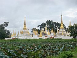 Pawrana Saeditaw Buddhist temple | |
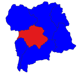 Location in Loilem district | |
| 21°16′20″N 97°39′10″E / 21.27222°N 97.65278°E / 21.27222; 97.65278 | |
| Country |  Burma Burma |
| State | Shan State |
| Shan | [Lai-Hka District] |
| Elevation | 971 m (3,186 ft) |
| Time zone | UTC+6.30 (MST) |
Lai-Hka Township (Shan: ဝဵင်းလၢႆးၶႃႈ), also known as Legya Township (Burmese: လဲချားမြို့နယ်), is the former capital of Laihka State, one of the former southern Shan States. The city has a population of over 60,000. It lays 3,116 feet (950 m) above sea level on the eastern border of Kesee and Nam Zang. In the south, it connects Panglong and Lui Lin. Its neighboring towns are Lokjok to the west and Merng Klueng to the north. The total area of Lai-Hka Township is 914.92 square miles (2,369.6 km2) and is divided into 7 divisions. The rural part of the township is divided into four quarters. Agriculture is the main industry in Lai-Hka.
History
Lai-Hka Township has had a turbulent and unstable history, with conflicts between the Shan State Army-South (SSA-S) and the Burmese Army. In the first half of 2009, there were at least four battles every month and the SPDC retaliated against villagers by confiscating property, extortion and forced relocation.
At the end of July 2009,[2] more than five hundred houses were burnt and 30 villages forcibly relocated in the township of Lai-Hka.[3]
On 6 August 2024, the district was the site of a skirmish between the Myanmar military and the Shan State Army.[4]
References
- ^ GoogleEarth
- ^ "Scorched earth victims ordered to rebuild houses". Burma Digest. August 28, 2008. Archived from the original on September 1, 2009.
- ^ "Southern Shan State". Thailand Burma Border Consortium. Archived from the original on March 28, 2010. Retrieved February 28, 2010.
- ^ "Military Council Suffers High Casualties in Laihka Township Battle". Burma News International. Retrieved 2024-01-31.
External links
 Media related to Lai-Hka Township at Wikimedia Commons
- v
- t
- e
Capital: Taunggyi
| Kengtung District |
|
|---|---|
| Mong Hpayak District |
|
| Mong Hsat District |
|
| Tachileik District |
|


| Kyaukme District |
|
|---|---|
| Lashio District | |
| Laukkaing District | see Kokang Self-Administered Zone |
| Mu Se District |
|
| Hopang District | see Wa Self-Administered Division |
| Matman District | see Wa Self-Administered Division |
| Mongmit District | |
| Kokang Self-Administered Zone |
|
| Pa Laung Self-Administered Zone1 | |
| Wa Self-Administered Division |
|
| Langkho District |
|
|---|---|
| Loilen District |
|
| Taunggyi District |
|
| Danu Self-Administered Zone | |
| Pa-O Self-Administered Zone |
- Taunggyi
- Aungban
- Ayetharyar
- Chinshwehaw
- Hong Pai
- Hopang
- Hopong
- Hseni
- Hsi Hseng
- Hsipaw
- Kalaw
- Kengtung
- Kunhing
- Kunlong
- Kutkai
- Kyaukme
- Kyethi
- Lai-Hka
- Langkho
- Lashio
- Laukkaing
- Lawksawk
- Loilen
- Mabein
- Mantong
- Mawkmai
- Mong Hpayak
- Mong Hsat
- Mong Hsu
- Mong Khet
- Mong Kung
- Mong Nai
- Mong Pan
- Mong Ping
- Mong Ton
- Mong Yang
- Mong Yawng
- Mongko
- Mongmit
- Mongyai
- Muse
- Nanhkan
- Namhsan
- Namtu
- Nansang
- Nawnghkio
- Nyaungshwe
- Panglong
- Pekon
- Pinlaung
- Ponparkyin, Shan State, Myanmar
- Tachileik
- Tangyan
1 - also part of Kyaukme District; 2 - also part of Hopang District; 3 - also part of Matman District
 | This Shan State location article is a stub. You can help Wikipedia by expanding it. |
- v
- t
- e


