Montgomery County, Maryland

Montgomery County, Maryland
Pusat kota Rockville pada tahun 2001, Black Rock Mill pada tahun 2006, National Naval Medical Center pada tahun 2003, Shady Grove pada tahun 2004, dan Balai Kota Gaithersburg pada tahun 2007
Flag of Montgomery County, Maryland
Bendera
Seal of Montgomery County, Maryland
Seal
Logo Montgomery County, Maryland
Logo
Motto: "Gardez Bien"
(Watch Well)
Map of Maryland highlighting Montgomery County
Lokasi di negara bagian Maryland
Map of the United States highlighting Maryland
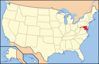
Lokasi negara bagian Maryland di Amerika Serikat
Didirikan1776
Asal namaRichard Montgomery
SeatRockville
community terbesarGermantown
Wilayah
 • Keseluruhan507 sq mi (1.313 km2)
 • Daratan496 sq mi (1.285 km2)
 • Perairan12 sq mi (31 km2), 2.3%
Populasi (est.)
 • (2013)1,016,677
 • Kepadatan1.959,2/sq mi (756,2/km²)
Distrik kongress3rd, 6th, 8th
Zona waktuTimur:
UTC-5 (EST) / -4 (EDT)
Situs webwww.montgomerycountymd.gov

Montgomery County adalah county yang terletak di Negara Bagian Maryland. Letaknya berada di utara Washington, D.C.. Berdasarkan Sensus 2010, jumlah penduduk di county ini mencapai 971,777 jiwa dan data tahun 2012 menunjukkan jumlah penduduk yang mencapai 1,004,709 jiwa.[1] County seat dari county ini berada di Rockville.[2] Nama County ini diambil dari Richard Montgomery, seorang legislator dari Maryland.

Referensi

  1. ^ "State & County QuickFacts". United States Census Bureau. Diarsipkan dari versi asli tanggal 2011-07-06. Diakses tanggal August 20, 2013. 
  2. ^ "Find a County". National Association of Counties. Diakses tanggal 2011-06-07. 
  • l
  • b
  • s
Munisipalitas dan komunitas di Montgomery County, Maryland
Ibu kota county: Rockville
Kota
Kota kecil
  • Barnesville
  • Brookeville
  • Chevy Chase
  • Chevy Chase View
  • Chevy Chase Village
  • Garrett Park
  • Glen Echo
  • Kensington
  • Laytonsville
  • Poolesville
  • Somerset
  • Washington Grove
Desa & Distrik
Berpajak Khusus
  • Chevy Chase Section Three
  • Chevy Chase Section Five
  • Drummond
  • Friendship Heights
  • Martin's Additions
  • North Chevy Chase
  • Oakmont
CDP
  • Ashton-Sandy Spring
  • Aspen Hill
  • Bethesda
  • Brookmont
  • Burtonsville
  • Cabin John
  • Calverton‡
  • Chevy Chase
  • Clarksburg
  • Cloverly
  • Colesville
  • Damascus
  • Darnestown
  • Derwood
  • Fairland
  • Forest Glen
  • Four Corners
  • Friendship Heights Village
  • Germantown
  • Glenmont
  • Hillandale‡
  • Kemp Mill
  • Layhill
  • Leisure World
  • Montgomery Village
  • North Bethesda
  • North Kensington
  • North Potomac
  • Olney
  • Potomac
  • Redland
  • Silver Spring
  • South Kensington
  • Spencerville
  • Travilah
  • Wheaton
  • White Oak
Komunitas
tak berhubungan
  • Ashton
  • Beallsville
  • Boyds
  • Brinklow
  • Carderock
  • Carole Highlands
  • Chevy Chase
  • Comus
  • Dawsonville
  • Dickerson
  • Ednor
  • Fairview
  • Forest Glen Park
  • Hyattstown
  • Kentlands
  • Norbeck
  • Norwood
  • Quince Orchard
  • Scotland
  • Seneca
  • Sandy Spring
  • Shady Grove
  • Sherwood Forest
  • Thompson's Corner
Catatan

‡Tempat berpenduduk ini juga merupakan bagian di county yang berdekatan

  • l
  • b
  • s
 Negara bagian Maryland
Annapolis (ibu kota)
Topik
  • Cities
  • Government
  • History
  • People
  • Congressional Delegations
  • Congressional Maps
  • Economy
  • List of Maryland-related topics
  • Visitor Attractions
Wilayah
  • Allegheny Mountains
  • Atlantic Coastal Plain
  • Baltimore‑Washington Metro Area
  • Blue Ridge
  • Chesapeake
  • Cumberland Valley
  • Delaware Valley
  • Delmarva Peninsula
  • Eastern Shore
  • Piedmont
  • Ridge and Valley
  • Southern Maryland
  • Western Maryland
  • Western Shore
Kota besar
Kota sensus
  • Adelphi
  • Arbutus
  • Arnold
  • Aspen Hill
  • Ballenger Creek
  • Bel Air North
  • Bel Air South
  • Bethesda
  • Brooklyn Park
  • Calverton
  • Camp Springs
  • Carney
  • Catonsville
  • Chesapeake Ranch Estates-Drum Point
  • Chillum
  • Clinton
  • Cockeysville-Hunt Valley
  • Colesville
  • Columbia
  • Coral Hills
  • Crofton
  • Damascus
  • Dundalk
  • East Riverdale
  • Edgewood
  • Eldersburg
  • Elkridge
  • Ellicott City
  • Essex
  • Fairland
  • Ferndale
  • Forestville
  • Fort Washington
  • Friendly
  • Germantown
  • Glen Burnie
  • Glenn Dale
  • Greater Landover
  • Greater Upper Marlboro
  • Green Haven
  • Green Valley
  • Halfway
  • Hillcrest Heights
  • Joppatowne
  • Kettering
  • Lake Shore
  • Langley Park
  • Lanham-Seabrook
  • Lansdowne-Baltimore Highlands
  • Lexington Park
  • Linganore-Bartonsville
  • Lochearn
  • Lutherville-Timonium
  • Mays Chapel
  • Middle River
  • Milford Mill
  • Montgomery Village
  • North Bethesda
  • North Laurel
  • North Potomac
  • Ocean Pines
  • Odenton
  • Olney
  • Overlea
  • Owings Mills
  • Oxon Hill-Glassmanor
  • Parkville
  • Parole
  • Pasadena
  • Perry Hall
  • Pikesville
  • Potomac
  • Randallstown
  • Redland
  • Reisterstown
  • Riviera Beach
  • Rosaryville
  • Rosedale
  • Rossville
  • St. Charles
  • Savage-Guilford
  • Severn
  • Severna Park
  • Silver Spring
  • South Gate
  • South Laurel
  • Suitland-Silver Hill
  • Towson
  • Waldorf
  • Walker Mill
  • Wheaton-Glenmont
  • White Oak
  • Woodlawn
County

Artikel bertopik Amerika Serikat ini adalah sebuah rintisan. Anda dapat membantu Wikipedia dengan mengembangkannya.

  • l
  • b
  • s