Tora Wari
Federally Administered Tribal Areas in Khyber Pakhtunkhwa, Pakistan
Torawari طوراوڑی | |
|---|---|
Federally Administered Tribal Areas | |
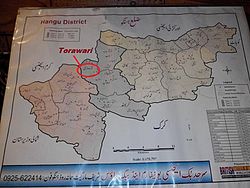 Location of Torawari in Tehsil Thal . Hangu District | |
| Coordinates: 33°22′47″N 70°43′27.47″E / 33.37972°N 70.7242972°E / 33.37972; 70.7242972 | |
| Country |  Pakistan Pakistan |
| Region | Khyber Pakhtunkhwa |
| District | Hangu District |
| Tehsil | Thall |
| Province | Federally Administered Tribal Areas |
| Continent | Asia |
| Elevation | 969 m (3,179 ft) |
| Time zone | UTC+5 (PST) |
Torawari(طوراوڑی) is a village with a small population. Torawari was a part of Federally Admisinstred Tribal Areas (F.A.T.A). But recently in 2019 bill was passed under the government of Prime Minister Imran Khan and he approved it. Now its Torawari, Khyber PakhtunKhwa, Pakistan. Torawari which is located in the Tehsil Thal Hangu District in Khyber Pakhtunkhwa, Pakistan.[1]
Torawari is bordered by Kuram agency to the north, Naryab to the east, Darsamand to the west, and Doaba to the south.
Tribes
The main tribe living in Torawari is Khuidad khel. Khado khel, Hassan khel, Bharat Khel, Bharam khel and Tappy are the sub tribes of khuidadkhail tribe.
-
 lak konrah of torawari
 -
 sight of torawari


References
- ^ Tehsils & Unions in the District of Hangu - Government of Pakistan Archived 2012-08-06 at archive.today

33°22′0″N 70°43′27″E / 33.36667°N 70.72417°E / 33.36667; 70.72417
 | This Hangu District location article is a stub. You can help Wikipedia by expanding it. |
- v
- t
- e


