Tandai, Honiara
Suburb in Guadalcanal, Honiara Town, Solomon Islands
9°25′S 159°55′E / 9.417°S 159.917°E / -9.417; 159.917 Solomon Islands
 (2009)
Tandai is a suburb of Honiara, in the Solomon Islands, located 2 kilometres (1.2 mi) west of the main center on the Tandai Highway.[2] Tandai is in the Honiara City Council ward of Nggosi.[3]
Tandai is east of White River and west of Rove.
RAMSI
The former RAMSI HQ was located at Leilei, Tandai.
Land disputes
On Friday 26 June 2009, Solomon Islands Parliament passed a private member's motion [4] calling on the government to address land management and administration issues in Honiara. The motion moved by leader of the official independent group, Hon Isaac Inoke Tosika, member for West Honiara, sought to direct the government to urgently act to address the crisis in the management and administration of land in Honiara, including: Providing resources and technical assistance to the Ministry of Lands to address land management issues such as the need to acquire and subdivide undeveloped Fixed Term Estates such as those in Tandai, West Honiara, and where appropriate make them available to citizens who have had long term residency on those lands.
Squatter settlements in the Tandai area were caused by people who had settled on government land under temporary occupancy leases were evicted after the land was then allocated to foreign companies.
Tandai Land owning tribes and the Honiara City Council have engaged in a boundary consultation process to address the illegal Honiara City Boundary expansion [5]
By the end of the twentieth century, much urban growth was taking place in Tandai, causing planning problems related to provision of services and related issues, and also issues of access to land. These land issues became even more central during the ethnic tension and resulted in the evacuation of some of these areas in this period, although in many cases, agreements had been reached with traditional land owners.The urban area of Tandai more than tripled over the decade with an annual growth rate of 12.8 percent,[1]
Churches
- Bishop's Dale Church of Melanesia, the Anglican church was the site of election rallies in 2004[6]
- Assembly of God Christian Life Center [7]
- Was built in 1986 and is the AoG HQ for Honiara with an estimated 100 members.
Villages
- Lower Tasahe
- Rifle Range
- Tavioa Ridge
Tourism
- Tropicana Motel
- Tandai motel
Oxfam
The Oxfam building is located in Tandai and there are four strands to Oxfam's work:[8]
- Gender justice
- Oxfam works with a local NGO called the Family Support Centre (FSC) to address gender based violence, sexual abuse and child abuse. FSC offer emergency accommodation, legal and counseling services, run educational programs, maintain a resource library and raise awareness of GBV and women and children’s rights. They work closely with support agencies such as the police, as well as NGOs.
- Capacity-building
- Oxfam strengthens FSC’s long term sustainability and organizational development.
- Community engagement
- Oxfam supports community members as facilitators to run workshops that look at social inclusion, gender stereotypes, violence triggers and alternative actions.
- Advocacy
- Oxfam encourages agencies including the government and the judiciary to work together to promote and ensure the safety of women.>
Utilities
The Tangai area is one of the lowest proportions of households with piped water,[1] although efforts are underway to extend this supply [9]
Photos of Tandai
-
 Bishops Dale church
 -
 Tandai Christian Life Center
 -
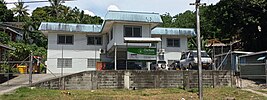 Oxfam building in Tandai
 -
 Tandai Service Station


References
- ^ a b c 2009 2009 POPULATION & HOUSING CENSUS. "Report on Migration and Urbanisation". Retrieved 26 April 2015.
{{cite web}}: CS1 maint: numeric names: authors list (link) - ^ Geographic Information Unit (June 2004). HONIARA LOCATION GUIDE. Department of Lands and Survey. p. 205.
- ^ Honiara City Council. "Ward Map". Archived from the original on 19 April 2015. Retrieved 19 April 2015.
- ^ "PRIVATE MEMBER MOTION ON LAND PASSED BY PARLIAMENT". National Parliament of Solomon Islands. Retrieved 26 April 2015.
- ^ "Tandai landowners slash demarcation proposal". Solomon Star. 17 September 2014. Retrieved 26 April 2015.
- ^ "Public attention focusses on first poll since RAMSI". 22 March 2012. Retrieved 26 April 2015.
- ^ RODOLFO MAGGIO. "Pentecostal Churches in Honiara" (PDF). Retrieved 26 April 2015.
- ^ "OXFAM Solomon Islands". Retrieved 26 April 2015.
- ^ "Solomon Water extends supply to West Honiara". Solomon Water. 16 April 2014. Retrieved 26 April 2015.
External links
- Tandai Facebook page
- v
- t
- e
Honiara
(West to East)
- Kakabona
- Water Pump
- White River
- Upper Tasahe
- Tandai
- Nggosi
- Rove
- Mbumburu
- Town Ground
- Mbokona
- Point Cruz
- Skyline
- Tuvaruhu
- Vuhokesa
- Chinatown
- Namoliki
- East Kola'a Ridge
- Naha
- Ferakusia
- Bahai Centre
- Kola'ale
- Mount Austen
- Fishing Village/Kukum
- Vura
- Gilbert Camp
- Panatina
- Jackson Ridge
- Ranadi
- Baranaba
- Nggeukama
- Panatina Creek
- Burns Creek
- King George
- King George Creek
- Lungga Point
- Lungga
- Betikama
- Lungga Plantation
- Sun Valley
- NZ Camp
- Henderson West
- Bloody Ridge
- Henderson Central
- Henderson East
- Matanikau River
- Lunga River
- Cathedral Church of St Barnabas
- Guadalcanal American Memorial
- Honiara Botanic Gardens
- Honiara Hotel
- Honiara International Airport
- Henderson Field
- Honiara Solomon Islands College of Higher Education
- Parliament House
- Lawson Tama Stadium
- Red House
- USP Solomon Islands campus
- Woodford International School


