Shigatse Peace Airport
Airport


RKZ
Location of airport in Tibet
| Direction | Length | Surface | |
|---|---|---|---|
| m | ft | ||
| 09/27 | 5,000 | 16,404 | Concrete |
| 07/25 | 3,000 | 9,843 | Concrete |
| Passengers | 144,870 |
|---|---|
| Aircraft movements | 1,804 |
| Cargo (metric tons) | 528.9 |
Source:[1]
| Shigatse Peace Airport | |||||||
|---|---|---|---|---|---|---|---|
| Chinese name | |||||||
| Simplified Chinese | 日喀则和平机场 | ||||||
| Traditional Chinese | 日喀則和平機場 | ||||||
| |||||||
| Tibetan name | |||||||
| Tibetan | གཞིས་ཀ་རྩེ་ཞི་བདེ་གནམ་གྲུ་ཐང། | ||||||
| |||||||
Rikaze (Shigatse) Peace Airport (IATA: RKZ, ICAO: ZURK), Shigatse Heping Airport, or Shigatse Air Base, is a dual-use military and civilian airport serving Shigatse, the second largest city in Tibet Autonomous Region, China. It is located in Jangdam Township,[2] 43 kilometres (27 mi) from Shigatse. Situated at an elevation of 3,782 metres (12,408 ft), it is one of the highest airports in the world.[2]
Construction of Shigatse Airport started in 1968 and was completed in 1973. It was solely for military use until 2010, when a 532 million yuan expansion was completed. On 30 October 2010, the airport was opened as the fifth civilian airport in Tibet.[3]
Facilities
The airport has a 5,000-metre (16,000 ft) runway with a 60-metre (200 ft) asphalt overrun at each end. It is the longest public runway in the world (tied with Ulyanovsk Vostochny Airport).[4] It also features a 4,500-square-metre (48,000 sq ft) terminal building. It is projected to handle 230,000 passengers and 1,150 tonnes (1,130 long tons; 1,270 short tons) of cargo annually by 2020.[3][1]
Around 2017, a new runway of approximately 3,000 metres (9,840 ft) was constructed. Guizhou WZ-7 Soaring Dragon UAVs were seen hosted by this runway. The runway is located at the west-end of its primary runway.[5]
Gallery
-
 Inside the terminal
 -
 Airport taxiways
 -
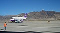 Airport taxiways
 -
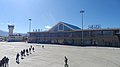 Airport terminal (a view from tarmac)
 -
 Satellite view of the airport (2017)


Airlines and destinations
| Airlines | Destinations |
|---|---|
| China Eastern Airlines | Xi'an |
| Tibet Airlines | Chengdu–Shuangliu, Xi'an |
| West Air | Chongqing[6] |
Map and location markers


300m
330yds
330yds

4
3
2
1
Key:
1
Runway 1 (16,404ft)2
Runway 2 (9,843ft)3
Main Terminal4
Air Traffic Control towerSee also
- List of airports in China
- List of the busiest airports in China
- List of People's Liberation Army Air Force airbases
References
- ^ a b Airport information for Shigatse Airport at Great Circle Mapper.
- ^ a b 西藏第五个民用机场日喀则机场正式通航 (in Chinese (China)). Xinhua. 2010-10-30. Archived from the original on November 2, 2010.
- ^ a b 西藏第五个民用机场日喀则机场正式通航 (in Chinese (China)). Xinhua. 2010-10-30. Archived from the original on November 2, 2010.
- ^ Loh, Chris; Ahlgren, Linnea (2020-07-27). "What Are The Longest Runways In The World?". Simple Flying. Retrieved 2024-01-10.
- ^ Team, Bellingcat Investigation (2017-11-28). "China's Shigatse Gets New Infrastructure". bellingcat. Retrieved 2024-01-10.
- ^ "China West Air flight PN6450". Flightradar24.
Wikimedia Commons has media related to Shigatse Peace Airport.
- v
- t
- e
| Beijing | |
|---|---|
| Tianjin | |
| Hebei | |
| Shanxi | |
| Inner Mongolia | |
| Liaoning | |
|---|---|
| Jilin | |
| Heilongjiang | |
| Shanghai | |
|---|---|
| Jiangsu | |
| Zhejiang | |
| Anhui | |
| Fujian | |
| Jiangxi | |
| Shandong | |
| Henan | |
|---|---|
| Hubei | |
| Hunan | |
| Guangdong | |
| Guangxi | |
| Hainan | |
| Chongqing | |
|---|---|
| Sichuan | |
| Guizhou | |
| Yunnan | |
| Tibet | |
| Shaanxi | |
|---|---|
| Gansu | |
| Qinghai | |
| Ningxia | |
| Xinjiang | |
Under construction | |
|---|---|
Note: bold indicates international airports.
 Public transportation in Tibet, China (XZ) Public transportation in Tibet, China (XZ) | |||||
|---|---|---|---|---|---|
 CR Major railways CR Major railways |
| ||||
| Transportation hubs |
| ||||
| |||||


