Sellye District
Districts of Hungary in Baranya
Sellye District Sellyei járás | |
|---|---|
Districts of Hungary | |
 Coat of arms | |
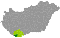 Sellye District within Hungary and Baranya County. | |
| Coordinates: 45°52′N 17°51′E / 45.87°N 17.85°E / 45.87; 17.85 | |
| Country |  Hungary Hungary |
| County | Baranya |
| District seat | Sellye |
| Area | |
| • Total | 493.69 km2 (190.61 sq mi) |
| • Rank | 5th in Baranya |
| Population (2011 census) | |
| • Total | 14,192 |
| • Rank | 7th in Baranya |
| • Density | 29/km2 (80/sq mi) |
Sellye (Hungarian: Sellyei járás) is a district in south-western part of Baranya County, Hungary. Sellye is also the name of the town that is the location of the district seat. The district is located in the Southern Transdanubia Statistical Region.
Geography
Sellye District borders with Szigetvár District and Szentlőrinc District to the north, Pécs District and Siklós District to the east, the Croatian counties of Virovitica-Podravina and Osijek-Baranja to the south, Barcs District (Somogy County) to the west. The number of the inhabited places in Sellye District is 38.
Municipalities
The district has 1 town, 1 large village and 36 villages. (ordered by population, as of 1 January 2012)[1]
- Adorjás (181)
- Baksa (769)
- Baranyahídvég (202)
- Besence (121)
- Bogádmindszent (431)
- Bogdása (276)
- Csányoszró (668)
- Drávafok (503)
- Drávaiványi (196)
- Drávakeresztúr (109)
- Drávasztára (398)
- Felsőszentmárton (881)
- Gilvánfa (369)
- Hegyszentmárton (408)
- Hirics (232)
- Kákics (227)
- Kemse (57)
- Kisasszonyfa (178)
- Kisszentmárton (261)
- Kórós (222)
- Lúzsok (266)
- Magyarmecske (309)
- Magyartelek (216)
- Markóc (55)
- Marócsa (86)
- Nagycsány (152)
- Okorág (167)
- Ózdfalu (177)
- Páprád (153)
- Piskó (241)
- Sámod (217)
- Sellye (2,752) – district seat
- Sósvertike (184)
- Tengeri (47)
- Téseny (323)
- Vajszló (1,694)
- Vejti (160)
- Zaláta (278)
The bolded municipality is city, italics municipality is large village.
See also
References
- ^ A KSH 2012. évi helységnévkönyve
External links
- Postal codes of the Sellye District
- v
- t
- e
- Sellye (district seat)

- Adorjás
- Baksa
- Baranyahídvég
- Besence
- Bogádmindszent
- Bogdása
- Csányoszró
- Drávafok
- Drávaiványi
- Drávakeresztúr
- Drávasztára
- Felsőszentmárton
- Gilvánfa
- Hegyszentmárton
- Hirics
- Kákics
- Kemse
- Kisasszonyfa
- Kisszentmárton
- Kórós
- Lúzsok
- Magyarmecske
- Magyartelek
- Markóc
- Marócsa
- Nagycsány
- Okorág
- Ózdfalu
- Páprád
- Piskó
- Sámod
- Sósvertike
- Tengeri
- Téseny
- Vejti
- Zaláta
Authority control databases | |
|---|---|
| International |
|
| National |
|
 | This Baranya County–related article is a stub. You can help Wikipedia by expanding it. |
- v
- t
- e


