Raschau-Markersbach
You can help expand this article with text translated from the corresponding article in German. (August 2012) Click [show] for important translation instructions.
- View a machine-translated version of the German article.
- Machine translation, like DeepL or Google Translate, is a useful starting point for translations, but translators must revise errors as necessary and confirm that the translation is accurate, rather than simply copy-pasting machine-translated text into the English Wikipedia.
- Do not translate text that appears unreliable or low-quality. If possible, verify the text with references provided in the foreign-language article.
- You must provide copyright attribution in the edit summary accompanying your translation by providing an interlanguage link to the source of your translation. A model attribution edit summary is
Content in this edit is translated from the existing German Wikipedia article at [[:de:Raschau-Markersbach]]; see its history for attribution. - You may also add the template
{{Translated|de|Raschau-Markersbach}}to the talk page. - For more guidance, see Wikipedia:Translation.
Municipality in Saxony, Germany
Raschau-Markersbach | ||
|---|---|---|
Municipality | ||
Location of Raschau-Markersbach within Erzgebirgskreis district  | ||
(2022–29) Frank Tröger[1] | | |
| Area | ||
| • Total | 39.52 km2 (15.26 sq mi) | |
| Highest elevation | 830 m (2,720 ft) | |
| Lowest elevation | 420 m (1,380 ft) | |
| Population (2022-12-31)[2] | ||
| • Total | 4,890 | |
| • Density | 120/km2 (320/sq mi) | |
| Time zone | UTC+01:00 (CET) | |
| • Summer (DST) | UTC+02:00 (CEST) | |
| Postal codes | 08352 | |
| Dialling codes | 03774 | |
| Vehicle registration | ERZ, ANA, ASZ, AU, MAB, MEK, STL, SZB, ZP | |
| Website | www.markersbach.de | |
Raschau-Markersbach is a municipality in the district of Erzgebirgskreis in Saxony, Germany. It was formed on 1 January 2008, by the merger of the former municipalities Markersbach and Raschau.[3]
Gallery
-
 Ruins of the lime plant
 -
-
-
 Looking through the bridge under construction of the bypass stream marker (B101) on the marker Bacher Viaduct
 -
 Pumped storage plant markers (Bach Dam)
 -
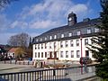 Elementary school
 -

-

-


References
- ^ Gewählte Bürgermeisterinnen und Bürgermeister im Freistaat Sachsen, Stand: 17. Juli 2022, Statistisches Landesamt des Freistaates Sachsen.
- ^ "Einwohnerzahlen nach Gemeinden als Excel-Arbeitsmappe" (XLS) (in German). Statistisches Landesamt des Freistaates Sachsen. 2024.
- ^ Gebietsänderungen vom 01.01. bis 31.12.2008, Statistisches Bundesamt
Wikimedia Commons has media related to Raschau-Markersbach.
- v
- t
- e
Towns and municipalities in Erzgebirgskreis
- Amtsberg
- Annaberg-Buchholz
- Aue-Bad Schlema
- Auerbach
- Bärenstein
- Bockau
- Börnichen
- Breitenbrunn
- Burkhardtsdorf
- Crottendorf
- Deutschneudorf
- Drebach
- Ehrenfriedersdorf
- Eibenstock
- Elterlein
- Gelenau
- Geyer
- Gornau
- Gornsdorf
- Großolbersdorf
- Großrückerswalde
- Grünhain-Beierfeld
- Grünhainichen
- Heidersdorf
- Hohndorf
- Jahnsdorf
- Johanngeorgenstadt
- Jöhstadt
- Königswalde
- Lauter-Bernsbach
- Lößnitz
- Lugau
- Marienberg
- Mildenau
- Neukirchen
- Niederdorf
- Niederwürschnitz
- Oberwiesenthal
- Oelsnitz
- Olbernhau
- Pockau-Lengefeld
- Raschau-Markersbach
- Scheibenberg
- Schlettau
- Schneeberg
- Schönheide
- Schwarzenberg
- Sehmatal
- Seiffen
- Stollberg
- Stützengrün
- Tannenberg
- Thalheim
- Thermalbad Wiesenbad
- Thum
- Wolkenstein
- Zschopau
- Zschorlau
- Zwönitz

Authority control databases | |
|---|---|
| International |
|
| National |
|
 | This Erzgebirgskreis location article is a stub. You can help Wikipedia by expanding it. |
- v
- t
- e


