Pestszentlőrinc-Pestszentimre
You can help expand this article with text translated from the corresponding article in Hungarian. (December 2009) Click [show] for important translation instructions.
- View a machine-translated version of the Hungarian article.
- Machine translation, like DeepL or Google Translate, is a useful starting point for translations, but translators must revise errors as necessary and confirm that the translation is accurate, rather than simply copy-pasting machine-translated text into the English Wikipedia.
- Consider adding a topic to this template: there are already 591 articles in the main category, and specifying
|topic=will aid in categorization. - Do not translate text that appears unreliable or low-quality. If possible, verify the text with references provided in the foreign-language article.
- You must provide copyright attribution in the edit summary accompanying your translation by providing an interlanguage link to the source of your translation. A model attribution edit summary is
Content in this edit is translated from the existing Hungarian Wikipedia article at [[:hu:Budapest XVIII. kerülete]]; see its history for attribution. - You may also add the template
{{Translated|hu|Budapest XVIII. kerülete}}to the talk page. - For more guidance, see Wikipedia:Translation.
District of Budapest in Central Hungary, Hungary
18th District of Budapest Budapest XVIII. kerülete Pestszentlőrinc‑Pestszentimre | |
|---|---|
| District XVIII | |
 Flag  Coat of arms | |
 Location of District XVIII in Budapest (shown in grey) | |
| Coordinates: 47°26′N 19°12′E / 47.433°N 19.200°E / 47.433; 19.200 | |
| Country | Hungary |
| Region | Central Hungary |
| City | Budapest |
| Established | 1 January 1950 |
| Quarters[1] | List
|
| Government | |
| • Mayor | Sándor Szaniszló (DK) |
| Area | |
| • Total | 38.60 km2 (14.90 sq mi) |
| • Rank | 4th |
| Population (2016)[2] | |
| • Total | 101,738 |
| • Rank | 5th |
| • Density | 2,635/km2 (6,820/sq mi) |
| Demonym | tizennyolcadik kerületi ("18th districter") |
| Time zone | UTC+1 (CET) |
| • Summer (DST) | UTC+2 (CEST) |
| Postal code | 1181 ... 1188 |
| Website | www |
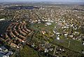
Pestszentlőrinc‑Pestszentimre (also known as Budapest XVIII. kerülete; German: Sankt Lorenz-Sankt Emmerich) is the 18th district of Budapest and is situated at the south-eastern part of the city. It is made up of two earlier distinct towns: Pestszentlőrinc and Pestszentimre.
The population of the district today is around 100.000 and this amount is divided between the two divisions as 80%-20%. The area joined Budapest shortly after World War II (see Great-Budapest).
Budapest's international airport (Ferihegy Airport), the Hungarian Meteorological Service and the Central Atmospheric Institute are located here.
| Climate data for Pestszentlőrinc, Budapest (1991-2020) elevation: 139 | |||||||||||||
|---|---|---|---|---|---|---|---|---|---|---|---|---|---|
| Month | Jan | Feb | Mar | Apr | May | Jun | Jul | Aug | Sep | Oct | Nov | Dec | Year |
| Mean daily maximum °C (°F) | 3.0 (37.4) | 5.8 (42.4) | 11.3 (52.3) | 17.9 (64.2) | 22.6 (72.7) | 26.2 (79.2) | 28.1 (82.6) | 28.0 (82.4) | 22.5 (72.5) | 16.4 (61.5) | 9.4 (48.9) | 3.5 (38.3) | 16.2 (61.2) |
| Daily mean °C (°F) | 0.0 (32.0) | 2.0 (35.6) | 6.6 (43.9) | 12.4 (54.3) | 16.9 (62.4) | 20.7 (69.3) | 22.5 (72.5) | 22.3 (72.1) | 16.9 (62.4) | 11.3 (52.3) | 5.9 (42.6) | 0.8 (33.4) | 11.5 (52.7) |
| Mean daily minimum °C (°F) | −2.5 (27.5) | −1.3 (29.7) | 2.3 (36.1) | 7.1 (44.8) | 11.6 (52.9) | 15.2 (59.4) | 16.7 (62.1) | 16.6 (61.9) | 12.2 (54.0) | 7.2 (45.0) | 3.1 (37.6) | −1.4 (29.5) | 7.2 (45.0) |
| Average precipitation mm (inches) | 31.0 (1.22) | 31.3 (1.23) | 31.5 (1.24) | 34.6 (1.36) | 64.8 (2.55) | 65.0 (2.56) | 74.0 (2.91) | 58.7 (2.31) | 51.3 (2.02) | 44.0 (1.73) | 46.8 (1.84) | 38.5 (1.52) | 571.5 (22.49) |
| Average precipitation days (≥ 1.0 mm) | 6.1 | 5.6 | 5.9 | 5.7 | 8.4 | 6.6 | 7.6 | 5.3 | 5.5 | 6.2 | 7.0 | 7.1 | 77 |
| Average relative humidity (%) | 84 | 77 | 66 | 59.2 | 63.4 | 63.9 | 62 | 62.9 | 69.2 | 76.8 | 83 | 84.7 | 71.0 |
| Source: NOAA[3] | |||||||||||||
List of mayors
| Member | Party | Date | |
|---|---|---|---|
| Endre Molich | SZDSZ | 1990–1994 | |
| László Mester | MSZP | 1994–2010 | |
| Attila Ughy | Fidesz | 2010–2019 | |
| Sándor Szaniszló | DK | 2019– | |
Twin towns - twin cities
Pestszentlőrinc-Pestszentimre is twinned with:
 Băile Tușnad – Romania
 Dąbrowa Tarnowska – Poland
 Artashat – Armenia
 Nin – Croatia
 San Nicola la Strada – Italy
 Nesebar – Bulgaria
 Roding – Germany
- Obzor – Bulgaria
- Izvoru Crișului – Romania
 Moldava nad Bodvou – Slovakia
 Tiachiv – Ukraine
- Odorheiu Secuiesc – Romania


Gallery


References
- ^ "94/2012. (XII. 27.) Főv. Kgy. rendelet - a közterület- és városrésznevek megállapításáról, azok jelöléséről, valamint a házszám-megállapítás szabályairól" (in Hungarian).
- ^ a b "A fővárosi kerületek, a megyei jogú városok, a városok területe, lakónépessége és a lakások száma" [The area of districts of the capital, of the towns with county's rights, resident population and number of dwellings]. Magyarország közigazgatási helynévkönyve 2016. január 1 [Gazetteer of Hungary 1st January, 2016] (PDF). Hungarian Central Statistical Office. 2016. p. 21.
- ^ "World Meteorological Organization Climate Normals for 1991-2020: Budapest-Pestszentlőrinc" (CSV). ncei.noaa.gov. NOAA. Retrieved 18 January 2024.
External links
- Official site (Hungarian)
- Aerial photographs of Pestszentlőrinc
- v
- t
- e

- I. Várkerület
- II. 2nd district
- III. Óbuda-Békásmegyer
- IV. Újpest
- V. Belváros-Lipótváros
- VI. Terézváros
- VII. Erzsébetváros
- VIII. Józsefváros
- IX. Ferencváros
- X. Kőbánya
- XI. Újbuda
- XII. Hegyvidék
- XIII. 13th district
- XIV. Zugló
- XV. 15th district
- XVI. 16th district
- XVII. Rákosmente
- XVIII. Pestszentlőrinc-Pestszentimre
- XIX. Kispest
- XX. Pesterzsébet
- XXI. Csepel
- XXII. Budafok-Tétény
- XXIII. Soroksár
traditions
- Budapest Business School
- Budapest University of Technology
- Corvinus University
- Eötvös Loránd University
- Hungarian University of Fine Arts
- Liszt Ferenc Academy of Music
- Moholy-Nagy University of Art and Design
- National University of Public Service
- Óbuda University
- Semmelweis University
- University of Physical Education
- Academy of Drama and Film
- Andrássy University
- Aquincum Institute of Technology
- Budapest Metropolitan University
- Budapest University of Jewish Studies
- Central European University
- International Business School
- Károli Gáspár University of Reformed Church
- Pázmány Péter Catholic University
 History of Budapest
 Category


| ||
|---|---|---|
|  | |
  | This Hungarian history article is a stub. You can help Wikipedia by expanding it. |
- v
- t
- e
 | This Budapest location article is a stub. You can help Wikipedia by expanding it. |
- v
- t
- e


