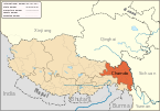
Pasho County
County in Tibet, China
Pasho County 30°3′25″N 96°55′7″E / 30.05694°N 96.91861°E / 30.05694; 96.91861 | |
|---|---|
| Country | China |
| Autonomous region | Tibet |
| Prefecture-level city | Chamdo |
| County seat | Baima (Pasho) |
| Area | |
| • Total | 12,328.31 km2 (4,759.99 sq mi) |
| Population (2020)[1] | |
| • Total | 43,538 |
| • Density | 3.5/km2 (9.1/sq mi) |
| Time zone | UTC+8 (China Standard) |
| Website | basu |
| Pasho County | |||||||||||
|---|---|---|---|---|---|---|---|---|---|---|---|
| Chinese name | |||||||||||
| Simplified Chinese | 八宿县 | ||||||||||
| Traditional Chinese | 八宿縣 | ||||||||||
| |||||||||||
| Tibetan name | |||||||||||
| Tibetan | དཔའ་ཤོད་རྫོང་། | ||||||||||
| |||||||||||
Pasho County[2][a] or Baxoi County (Tibetan: དཔའ་ཤོད་རྫོང་།; Chinese: 八宿县) is a county under the administration of Chamdo Prefecture in the Tibet Autonomous Region, China. The county seat is at Pema, which is also called the "Pasho Town".[4] The county population is 35,273 (1999). It contains the Pomda Monastery and Rakwa Tso lake.
Administrative divisions
Pasho County is divided in 4 towns and 10 townships.
| Name | Chinese | Hanyu Pinyin | Tibetan | Wylie | ||
|---|---|---|---|---|---|---|
| Town | ||||||
| Baima (Pema, Pasho) | 白玛镇 | Báimǎ zhèn | པད་མ་གྲོང་རྡལ། | pad ma grong rdal | ||
| Bangda Town | 帮达镇 | Bāngdá zhèn | སྤང་མདའ་གྲོང་རྡལ། | spang mda' grong rdal | ||
| Ra'og Town | 然乌镇 | Ránwū zhèn | རྭ་འོག་གྲོང་རྡལ། | rwa 'og grong rdal | ||
| Tanggar Town | 同卡镇 | Tóngkǎ zhèn | ཐང་དཀར་གྲོང་རྡལ། | thang dkar grong rdal | ||
| Townships | ||||||
| Korqên Township | 郭庆乡 | Guōqìng xiāng | འཁོར་ཆེན་ཤང་། | 'khor chen shang | ||
| Lagê Township | 拉根乡 | Lāgēn xiāng | གླ་སྐེ་ཤང་། | gla ske shang | ||
| Yiqên Township | 益庆乡 | Yìqìng xiāng | ཡིད་ཆེན་ཤང་། | yid chen shang | ||
| Jirong Township | 集中乡 | Jízhōng xiāng | དཀྱིལ་གྲོང་ཤང་། | dkyil grong shang | ||
| Karwa pêkyim Township | 卡瓦白庆乡 | Kǎwǎbáiqìng xiāng | མཁར་བ་འཕེལ་ཁྱིམ་ཤང་། | mkhar ba 'phel khyim shang | ||
| Gyêda Township | 吉达乡 | Jídá xiāng | སྐྱེ་མདའ་ཤང་། | skye mda' shang | ||
| Gyari Township | 夏里乡 | Xiàlǐ xiāng | སྐྱ་རི་ཤང་། | skya ri shang | ||
| Yangpa Township | 拥乡 | Yōng xiāng | ཡངས་པ་ཤང་། | yangs pa shang | ||
| Wa Township | 瓦乡 | Wǎ xiāng | ཝ་ཤང་། | wa shang | ||
| Lingka Township | 林卡乡 | Línkǎ xiāng | གླིང་ཁ་ཤང་། | gling kha shang | ||
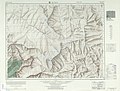
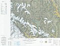
Geography
The Pasho County contains the Brahmaputra–Salween water divide. The Ngajuk La pass (29°40′07″N 96°43′05″E / 29.6687°N 96.7181°E / 29.6687; 96.7181 (Ngajuk La)) is on the divide. To the north, Ling Chu flows north and east draning into Salween. To the south, Parlung Tsangpo flows south and west to drain into the Tsangpo River (the Tibetan section of Brahmaputra).[5][6]
Climate
| Climate data for Pasho (1991–2019 normals, extremes 1981–2010) | |||||||||||||
|---|---|---|---|---|---|---|---|---|---|---|---|---|---|
| Month | Jan | Feb | Mar | Apr | May | Jun | Jul | Aug | Sep | Oct | Nov | Dec | Year |
| Record high °C (°F) | 18.4 (65.1) | 19.6 (67.3) | 25.0 (77.0) | 25.4 (77.7) | 30.3 (86.5) | 31.9 (89.4) | 33.4 (92.1) | 31.6 (88.9) | 32.0 (89.6) | 27.9 (82.2) | 22.0 (71.6) | 17.7 (63.9) | 33.4 (92.1) |
| Mean daily maximum °C (°F) | 9.1 (48.4) | 11.2 (52.2) | 13.8 (56.8) | 17.2 (63.0) | 21.6 (70.9) | 25.5 (77.9) | 26.1 (79.0) | 25.3 (77.5) | 24.1 (75.4) | 19.2 (66.6) | 14.1 (57.4) | 10.3 (50.5) | 18.1 (64.6) |
| Daily mean °C (°F) | 1.3 (34.3) | 4.0 (39.2) | 6.9 (44.4) | 10.5 (50.9) | 15.2 (59.4) | 19.0 (66.2) | 19.3 (66.7) | 18.4 (65.1) | 17.1 (62.8) | 12.1 (53.8) | 6.2 (43.2) | 2.0 (35.6) | 11.0 (51.8) |
| Mean daily minimum °C (°F) | −5.3 (22.5) | −2.4 (27.7) | 1.2 (34.2) | 5.1 (41.2) | 9.7 (49.5) | 14.0 (57.2) | 14.4 (57.9) | 13.6 (56.5) | 11.9 (53.4) | 6.4 (43.5) | −0.3 (31.5) | −4.7 (23.5) | 5.3 (41.6) |
| Record low °C (°F) | −14.9 (5.2) | −10.9 (12.4) | −8.5 (16.7) | −3.6 (25.5) | 0.6 (33.1) | 4.5 (40.1) | 7.4 (45.3) | 5.1 (41.2) | 1.0 (33.8) | −4.3 (24.3) | −9.5 (14.9) | −16.9 (1.6) | −16.9 (1.6) |
| Average precipitation mm (inches) | 0.3 (0.01) | 1.9 (0.07) | 8.5 (0.33) | 18.6 (0.73) | 21.5 (0.85) | 29.0 (1.14) | 62.6 (2.46) | 58.6 (2.31) | 31.9 (1.26) | 14.3 (0.56) | 2.6 (0.10) | 1.3 (0.05) | 251.1 (9.87) |
| Average precipitation days (≥ 0.1 mm) | 0.5 | 1.4 | 3.8 | 6.2 | 6.6 | 8.9 | 15.0 | 15.4 | 8.9 | 4.9 | 1.3 | 0.5 | 73.4 |
| Average snowy days | 1.2 | 2.4 | 4.0 | 2.0 | 0.2 | 0 | 0 | 0 | 0 | 0.5 | 1.6 | 0.8 | 12.7 |
| Average relative humidity (%) | 26 | 27 | 33 | 40 | 39 | 43 | 52 | 56 | 49 | 41 | 32 | 29 | 39 |
| Mean monthly sunshine hours | 212.9 | 223.8 | 252.8 | 245.7 | 260.9 | 232.9 | 201.4 | 199.4 | 218.9 | 233.1 | 216.8 | 207.6 | 2,706.2 |
| Percent possible sunshine | 65 | 71 | 68 | 63 | 61 | 55 | 47 | 49 | 60 | 67 | 69 | 66 | 62 |
| Source: China Meteorological Administration[7][8] | |||||||||||||
Transport

Maps
Notes
References
- ^ "昌都市第七次全国人口普查主要数据公报" (in Chinese). Government of Chamdo. 2021-06-22.
- ^ Dorje, Footprint Tibet (2004), p. 435.
- ^ Kingdon Ward & Smith, The Himalaya East of the Tsangpo (1934), p. 380.
- ^ Dorje, Footprint Tibet (2004), p. 436.
- ^ Dorje, Footprint Tibet (2004), pp. 436–437.
- ^ Kaulback, Ronald (1938). "A Journey in the Salween and Tsangpo Basins, South-Eastern Tibet". The Geographical Journal. 91 (2): 97–121. doi:10.2307/1788001. JSTOR 1788001.
- ^ 中国气象数据网 – WeatherBk Data (in Simplified Chinese). China Meteorological Administration. Retrieved 27 August 2023.
- ^ 中国气象数据网 (in Simplified Chinese). China Meteorological Administration. Retrieved 27 August 2023.
Bibliography
- Dorje, Gyurme (2004), Footprint Tibet Handbook with Bhutan (3rd ed.), Bath: Footprint Handbooks, ISBN 1-903471-30-3 – via archive.org
- Kingdon Ward, F.; Smith, Malcolm (November 1934), "The Himalaya East of the Tsangpo", The Geographical Journal, 84 (5): 369–394, doi:10.2307/1786924, JSTOR 1786924
External links
Wikimedia Commons has media related to Baxoi County.
- Pasho County, OpenStreetMap, retrieved 12 October 2022.
- Ling Chu basin, OpenStreetMap, retrieved 12 October 2022.
- v
- t
- e
Lhasa (capital)
cities
| Lhasa | |
|---|---|
| Xigazê | |
| Qamdo | |
| Nyingchi | |
| Shannan | |
| Nagqu |
| Ngari |
|---|
** Southern portions of these counties are claimed by the People's Republic of China as part of the South Tibet area, but are administered by India.