Ohanavan
40°20′32″N 44°23′11″E / 40.34222°N 44.38639°E / 40.34222; 44.38639
Place in Aragatsotn, Armenia
Ohanavan Օհանավան | |
|---|---|
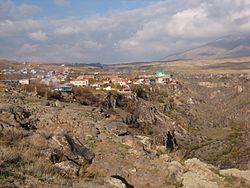 The village of Ohanavan. | |
  Ohanavan  Ohanavan | |
| Coordinates: 40°20′45″N 44°22′59″E / 40.34583°N 44.38306°E / 40.34583; 44.38306 | |
| Country | Armenia |
| Province | Aragatsotn |
| Municipality | Ashtarak |
| Population (2008) | |
| • Total | 2,414 |
| Time zone | UTC+4 |
| • Summer (DST) | UTC+5 |
Ohanavan (Armenian: Օհանավան) is a village in the Ashtarak Municipality of the Aragatsotn Province of Armenia. Ohanavan was resettled in 1828 by emigrants from Muş. On a nearby escarpment sits the 13th-century Hovhannavank Monastery. Both the town and the monastery are situated atop a steep gorge carved by the Kasagh river.
Gallery

References
Wikimedia Commons has media related to Ohanavan.
- Ohanavan at GEOnet Names Server
- World Gazetteer: Armenia[dead link] – World-Gazetteer.com
- Report of the results of the 2001 Armenian Census, Statistical Committee of Armenia
- Kiesling, Rediscovering Armenia, p. 21, available online at the US embassy to Armenia's website
- v
- t
- e
 Aragatsotn Province
Capital: Ashtarak

 | This article about a location in Aragatsotn Province, Armenia is a stub. You can help Wikipedia by expanding it. |
- v
- t
- e


