National Register of Historic Places listings in Allegany County, New York

Map all coordinates using OpenStreetMap
Download coordinates as:
- KML
- GPX (all coordinates)
- GPX (primary coordinates)
- GPX (secondary coordinates)
This is intended to be a complete list of properties and districts listed on the National Register of Historic Places in Allegany County, New York. The locations of National Register properties and districts for which the latitude and longitude coordinates are included below, may be seen in a map.[1]
This National Park Service list is complete through NPS recent listings posted June 7, 2024.[2]
| Albany (Albany) – Allegany – Bronx – Broome – Cattaraugus – Cayuga – Chautauqua – Chemung – Chenango – Clinton – Columbia – Cortland – Delaware – Dutchess (Poughkeepsie, Rhinebeck) – Erie (Buffalo) – Essex – Franklin – Fulton – Genesee – Greene – Hamilton – Herkimer – Jefferson – Kings – Lewis – Livingston – Madison – Monroe (Rochester) – Montgomery – Nassau – New York (Below 14th Street, 14th to 59th Streets, 59th to 110th Streets, Above 110th Street, Islands) – Niagara (Niagara Falls) – Oneida – Onondaga (Syracuse) – Ontario – Orange – Orleans – Oswego – Otsego – Putnam – Queens – Rensselaer – Richmond – Rockland – St. Lawrence – Saratoga – Schenectady – Schoharie – Schuyler – Seneca – Steuben – Suffolk – Sullivan – Tioga – Tompkins – Ulster – Warren – Washington – Wayne – Westchester (Northern, Southern, New Rochelle, Peekskill, Yonkers) – Wyoming – Yates |
Current listings
| [3] | Name on the Register | Image | Date listed[4] | Location | City or town | Description |
|---|---|---|---|---|---|---|
| 1 | Alfred Village Historic District |  | September 11, 1985 (#85002323) | Sections of N. & S. Main, Church, Ford, Glenn, Park, Sayles, Terrace & W. University Sts. 42°15′13″N 77°47′19″W / 42.2536°N 77.7886°W / 42.2536; -77.7886 (Alfred Village Historic District) | Alfred | |
| 2 | Alumni Hall | 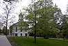 | September 12, 1985 (#85002389) | Alfred University 42°15′11″N 77°47′16″W / 42.2531°N 77.7878°W / 42.2531; -77.7878 (Alumni Hall) | Alfred | |
| 3 | Angelica Park Circle Historic District |  | January 31, 1978 (#78001840) | Main and White Sts. and Allegany County Fairgrounds 42°18′21″N 78°00′56″W / 42.3058°N 78.0156°W / 42.3058; -78.0156 (Angelica Park Circle Historic District) | Angelica | |
| 4 | Belmont Grange No. 1243 |  | January 18, 2006 (#05001533) | 32 Willets Ave. 42°13′30″N 78°02′25″W / 42.225°N 78.0403°W / 42.225; -78.0403 (Belmont Grange No. 1243) | Belmont | |
| 5 | Belmont Hotel |  | December 3, 2001 (#01001319) | 40-48 Schuyler St. 42°13′24″N 78°02′00″W / 42.2233°N 78.0333°W / 42.2233; -78.0333 (Belmont Hotel) | Belmont | |
| 6 | Belmont Literary and Historical Society Free Library |  | July 5, 2003 (#03000599) | 2 Willets Ave. 42°13′24″N 78°02′09″W / 42.2233°N 78.0358°W / 42.2233; -78.0358 (Belmont Literary and Historical Society Free Library) | Belmont | |
| 7 | Belvidere | 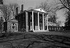 | March 16, 1972 (#72000822) | 3 mi. N of Belmont on SR 408 42°15′54″N 78°01′50″W / 42.265°N 78.0306°W / 42.265; -78.0306 (Belvidere) | Angelica | |
| 8 | Bolivar Free Library | Upload image | July 5, 2003 (#03000606) | 390 Main Street 42°03′55″N 78°03′44″W / 42.0654°N 78.0622°W / 42.0654; -78.0622 (Bolivar Free Library) | Bolivar | |
| 9 | Canaseraga Four Corners Historic District | Upload image | March 6, 2002 (#02000145) | 42-64 and 43-69 Main St., 9 S. Church St. 42°27′41″N 77°46′39″W / 42.4614°N 77.7775°W / 42.4614; -77.7775 (Canaseraga Four Corners Historic District) | Canaseraga | |
| 10 | Caneadea Bridge | 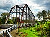 | November 19, 1998 (#98001388) | Cty. Rd. over Genesee R. 42°23′06″N 78°08′59″W / 42.385°N 78.1497°W / 42.385; -78.1497 (Caneadea Bridge) | Caneadea | |
| 11 | Centerville Town Hall | 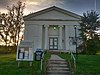 | March 25, 2009 (#09000154) | Fairview Road 42°28′44″N 78°14′58″W / 42.4790°N 78.2495°W / 42.4790; -78.2495 (Centerville Town Hall) | Centerville | |
| 12 | Ceres School | Upload image | December 7, 2010 (#10000991) | School St. 41°59′58″N 78°16′22″W / 41.9994°N 78.2728°W / 41.9994; -78.2728 (Ceres School) | Ceres | |
| 13 | Christ Episcopal Church | Upload image | May 17, 1974 (#74001218) | Gibson Hill Rd., SW of Rtes. 19 and 408 42°15′10″N 78°04′31″W / 42.2528°N 78.0753°W / 42.2528; -78.0753 (Christ Episcopal Church) | Belvidere | Now known as Belvidere Cornerstone |
| 14 | Cuba Cemetery | Upload image | February 12, 2015 (#15000004) | Medbury Ave. opposite Union St. 42°13′18″N 78°16′10″W / 42.2216°N 78.2695°W / 42.2216; -78.2695 (Cuba Cemetery) | Cuba | 1841 rural cemetery merged with adjacent Catholic cemetery in 1923 has graves of many early town residents |
| 15 | Fireman's Hall |  | March 18, 1980 (#80004275) | 7 W. University St. 42°15′13″N 77°47′29″W / 42.2536°N 77.7913°W / 42.2536; -77.7913 (Fireman's Hall) | Alfred | |
| 16 | Friendship Free Library |  | August 15, 2008 (#08000769) | 40 West Main Street 42°12′25″N 78°08′07″W / 42.2069°N 78.1354°W / 42.2069; -78.1354 (Friendship Free Library) | Friendship | |
| 17 | Main Street Historic District |  | February 5, 1999 (#99000087) | Roughly along Main St., from Orchard St. to Green St. 42°13′01″N 78°16′33″W / 42.2169°N 78.2758°W / 42.2169; -78.2758 (Main Street Historic District) | Cuba | |
| 18 | McKinney Stables of Empire City Farms |  | August 12, 1999 (#99001000) | 105 South St. 42°12′35″N 78°16′16″W / 42.2097°N 78.2711°W / 42.2097; -78.2711 (McKinney Stables of Empire City Farms) | Cuba | |
| 19 | Old Allegany County Courthouse | 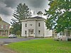 | August 21, 1972 (#72000821) | Park Circle 42°18′19″N 78°00′58″W / 42.3053°N 78.0161°W / 42.3053; -78.0161 (Old Allegany County Courthouse) | Angelica | |
| 20 | The Pink House | Upload image | March 3, 2021 (#100006214) | 193 West State St. 42°07′02″N 77°57′03″W / 42.1173°N 77.9509°W / 42.1173; -77.9509 (The Pink House) | Wellsville | |
| 21 | Rail and Titsworth Canal Warehouse |  | August 16, 2000 (#00000987) | Hughes Rd. 42°20′33″N 78°07′33″W / 42.3425°N 78.125833°W / 42.3425; -78.125833 (Rail and Titsworth Canal Warehouse) | Belfast | |
| 22 | The Reynolds House | Upload image | February 14, 2022 (#100007412) | 56 West University St. 42°15′12″N 77°47′43″W / 42.2533°N 77.7954°W / 42.2533; -77.7954 (The Reynolds House) | Alfred | |
| 23 | South Street Historic District |  | May 26, 1988 (#88000585) | 17, 19-89 South St. 42°12′50″N 78°16′31″W / 42.213889°N 78.275278°W / 42.213889; -78.275278 (South Street Historic District) | Cuba | |
| 24 | Allen Steinheim Museum |  | June 4, 1973 (#73001163) | Alfred University Campus 42°15′16″N 77°47′13″W / 42.254444°N 77.786944°W / 42.254444; -77.786944 (Allen Steinheim Museum) | Alfred | |
| 25 | Terra Cotta Building |  | March 16, 1972 (#72000820) | Main St. 42°15′27″N 77°47′19″W / 42.2575°N 77.788611°W / 42.2575; -77.788611 (Terra Cotta Building) | Alfred | |
| 26 | US Post Office-Wellsville |  | May 11, 1989 (#88002445) | 40 E. Pearl St. 42°07′24″N 77°56′56″W / 42.123333°N 77.948889°W / 42.123333; -77.948889 (US Post Office-Wellsville) | Wellsville | |
| 27 | Moses Van Campen House | 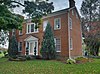 | April 16, 2004 (#04000287) | 4690 Birdsall Rd. 42°18′07″N 77°59′55″W / 42.301944°N 77.998611°W / 42.301944; -77.998611 (Moses Van Campen House) | Angelica | |
| 28 | Wellman House | Upload image | June 20, 1974 (#74001219) | Main St. 42°12′22″N 78°08′13″W / 42.206111°N 78.136944°W / 42.206111; -78.136944 (Wellman House) | Friendship | |
| 29 | Wellsville Erie Depot |  | August 27, 1987 (#87001426) | Depot St. 42°07′24″N 77°56′54″W / 42.123333°N 77.948333°W / 42.123333; -77.948333 (Wellsville Erie Depot) | Wellsville | |
| 30 | West Almond Churches | Upload image | August 2, 2000 (#00000876) | Cty. Rte. 2 42°17′59″N 77°53′07″W / 42.299722°N 77.885278°W / 42.299722; -77.885278 (West Almond Churches) | West Almond |
References
- ^ The latitude and longitude information provided in this table was derived originally from the National Register Information System, which has been found to be fairly accurate for about 99% of listings. Some locations in this table may have been corrected to current GPS standards.
- ^ National Park Service, United States Department of the Interior, "National Register of Historic Places: Weekly List Actions", retrieved June 7, 2024.
- ^ Numbers represent an alphabetical ordering by significant words. Various colorings, defined here, differentiate National Historic Landmarks and historic districts from other NRHP buildings, structures, sites or objects.
- ^ The eight-digit number below each date is the number assigned to each location in the National Register Information System database, which can be viewed by clicking the number.
External links
A useful list of the above sites, with street addresses and other information, is available at National Register of Historic Places.Com, a private site serving up public domain information on NRHPs.
- v
- t
- e
U.S. National Register of Historic Places in New York

by county
- Albany
- Allegany
- Bronx
- Broome
- Cattaraugus
- Cayuga
- Chautauqua
- Chemung
- Chenango
- Clinton
- Columbia
- Cortland
- Delaware
- Dutchess
- Erie
- Essex
- Franklin
- Fulton
- Genesee
- Greene
- Hamilton
- Herkimer
- Jefferson
- Kings (Brooklyn)
- Lewis
- Livingston
- Madison
- Monroe
- Montgomery
- Nassau
- New York (Manhattan)
- Niagara
- Oneida
- Onondaga
- Ontario
- Orange
- Orleans
- Oswego
- Otsego
- Putnam
- Queens
- Rensselaer
- Richmond (Staten Island)
- Rockland
- Saratoga
- Schenectady
- Schoharie
- Schuyler
- Seneca
- St. Lawrence
- Steuben
- Suffolk
- Sullivan
- Tioga
- Tompkins
- Ulster
- Warren
- Washington
- Wayne
- Westchester
- Wyoming
- Yates
by city
 Category
 List
List National Register of Historic Places Portal


Municipalities and communities of Allegany County, New York, United States | ||
|---|---|---|
County seat: Belmont | ||
| Towns |  | |
| Villages |
| |
| CDPs | ||
| Hamlets | ||
| Indian reservation | ||
| Footnotes | ‡This populated place also has portions in an adjacent county or counties | |
| ||
Wikimedia Commons has media related to National Register of Historic Places in Allegany County, New York.


