National Cycle Route 72
Cycle route in the United Kingdom
- Ravenglass
- South Shields/Tynemouth

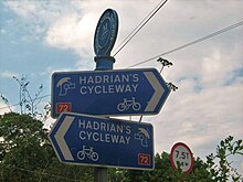
National Route 72 of the National Cycle Network, in Northern England is also called "Hadrian's Cycleway". It starts at Kendal and makes its way around the Cumbrian coast via Barrow-in-Furness and Whitehaven to Silloth, and then across the country through Carlisle via Newcastle upon Tyne to Tynemouth at the northern shore or to South Shields at the Tyne's south shore, where the cycleway ends at Arbeia Roman Fort. Much of its route is very close to Hadrian's Wall.
Kendal to Barrow in Furness is mapped on the Walney To Wear map. Ravenglass to Tynemouth is open and mapped on the Hadrian's Cycleway map, though some sections between Ravenglass and Silloth are using interim routes.
- v
- t
- e
Sustrans' National Cycle Network
routes
routes
- 125
- 136
- 137
- 141
- 151
- 155
- 162
- 164
- 165
- 166
- 167
- 168
- 169
- 172
- 174
- 177
- 178
- 179
- 195
- 196
- 207
- 208
- 212
- 221
- 222
- 223
- 224
- 231
- 232
- 235
- 236
- 244
- 246
- 248
- 250
- 253
- 254
- 255
- 256
- 264
- 267
- 270
- 272
- 273
- 274
- 275
- 276
- 277
- 278
- 305
- 326
- 334
- 338
- 339
- 341
- 344
- 403
- 410
- 413
- 416
- 423
- 425
- 426
- 436
- 437
- 438
- 439
- 440
- 442
- 446
- 447
- 448
- 451
- 455
- 461
- 465
- 466
- 467
- 468
- 469
- 475
- 476
- 477
- 478
- 481
- 482
- 485
- 492
- 523
- 524
- 525
- 526
- 533
- 534
- 535
- 536
- 539
- 544
- 547
- 548
- 549
- 550
- 552
- 554
- 555
- 558
- 559
- 561
- 562
- 566
- 568
- 573
- 576
- 577
- 585
- 622
- 627
- 633
- 636
- 645
- 646
- 647
- 648
- 656
- 657
- 658
- 665
- 668
- 672
- 674
- 677
- 680
- 688
- 689
- 696
- 697
- 699
- 700
- 715
- 725
- 753
- 754
- 756
- 764
- 765
- 766
- 767
- 768
- 775
- 776
- 777
- 780
- 810
- 811
- 818
- 819
- 820
- 822
- 825
- 862
- 881
- 882
- 883
- 884
- 885
- 887
routes
- C2C
- Celtic Trail
- Clyde to Forth
- Colliers Way
- Cornish Way
- Darent Valley Path
- Forth and Clyde Canal Pathway
- Hadrian's Cycleway
- Heron Trail
- Keelmans Way
- Lôn Cambria
- Lôn Las Ogwen
- Pennine Cycleway
- Mercian Way
- The North West Trail
- Salmon Run cycle route
- Scunthorpe Ridgeway
- Sheerness Way
- Trans Pennine Trail
- Viking Coastal Trail
- Way of the Roses
- White Rose cycle route
- W2W
- Yorkshire Wolds cycle route
External links
Wikimedia Commons has media related to National Cycle Network route 72.
- Official website

- Hadrian's Cycleway at cycle-routes.org
| Authority control databases |
|
|---|
54°20′58″N 3°24′22″W / 54.349535°N 3.406141°W / 54.349535; -3.406141


