Narciso Campero Province
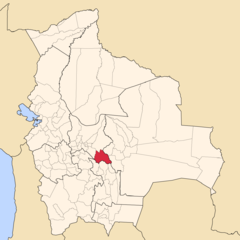
| Location of Narciso Campero Province within Bolivia | |
|---|---|
 | |
| General Data | |
| Country |  Bolivia Bolivia |
| Department | Cochabamba Department |
| Capital | Aiquile |
| Municipalities | 3 |
| Cantons | 10 |
| Area | 5,550 km2 |
| Elevation | m |
| Population | 37,011 (2001) |
| Density | 6.7 inhabitants/km2 (2001) |
| Sub-prefect | |
| Languages | Quechua, Spanish |
| ISO 3166-2 | BO.CB.CM |
| Cochabamba Department | |
 | |
Narciso Campero is a province in the Cochabamba Department, Bolivia. Its capital is Aiquile. Aiquile lies on one transportation route between the cities of Cochabamba, Sucre and Santa Cruz.
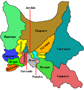
Subdivision
The province is divided into three municipalities which are further subdivided into cantons.
| Section | Municipality | Seat |
|---|---|---|
| 1st | Aiquile Municipality | Aiquile |
| 2nd | Pasorapa Municipality | Pasorapa |
| 3rd | Omereque Municipality | Omereque |
1998 earthquake
Campero was near the epicenter of an earthquake which struck on May 22, 1998. The shock had a moment magnitude of 6.6 and a maximum Mercalli intensity of VIII (Severe). It caused over 100 deaths and left thousands homeless. It was the largest shallow earthquake in Bolivia in over 50 years, and was felt as far away as Cochabamba and Sucre (approximately 100 km). The earthquake caused widespread damage over an area of approximately 100 km in diameter. The major towns affected were Hoyadas (100% of the buildings destroyed), Aiquile (75% of the buildings destroyed) and Totora (70% of the buildings destroyed).[1]
See also
Notes
External links
- Map of Narciso Campero Province
- v
- t
- e


Capital: Cochabamba
- Arani
- Arque
- Ayopaya
- Bolívar
- Capinota
- Carrasco
- Cercado
- Chapare
- Esteban Arce
- Germán Jordán
- Mizque
- Narciso Campero
- Punata
- Quillacollo
- Tapacarí
- Tiraque

(and seats)
- Aiquile (Aiquile)
- Alalay (Alalay)
- Anzaldo (Anzaldo)
- Arani (Arani)
- Arbieto (Arbieto)
- Arque (Arque)
- Ayopaya (Ayopaya)
- Bolívar (Bolívar)
- Capinota (Capinota)
- Chimoré (Chimoré)
- Cliza (Cliza)
- Cocapata (Cocapata)
- Cochabamba (Cochabamba)
- Colcapirhua (Colcapirhua)
- Colomi (Colomi)
- Cuchumuela (Cuchumuela)
- Entre Ríos Municipality (Entre Ríos)
- Mizque (Mizque)
- Morochata (Morochata)
- Omereque (Omereque)
- Pasorapa (Pasorapa)
- Pocona (Pocona)
- Pojo (Pojo)
- Puerto Villarroel (Puerto Villarroel)
- Punata (Punata)
- Quillacollo (Quillacollo)
- Sacaba (Sacaba)
- Sacabamba (Sacabamba)
- San Benito (San Benito)
- Santiváñez (Santiváñez)
- Shinahota (Shinahota)
- Sicaya (Sicaya)
- Sipe Sipe (Sipe Sipe)
- Tacachi (Tacachi)
- Tacopaya (Tacopaya)
- Tapacarí (Tapacarí)
- Tarata (Tarata)
- Tiquipaya (Tiquipaya)
- Tiraque (Tiraque)
- Toco (Toco)
- Tolata (Tolata)
- Totora (Totora)
- Vacas (Vacas)
- Vila Vila (Vila Vila)
- Villa Rivero (Villa Rivero)
- Villa Tunari (Villa Tunari)
- Vinto (Vinto)
Authority control databases | |
|---|---|
| International |
|
| National |
|
18°15′S 65°20′W / 18.250°S 65.333°W / -18.250; -65.333
This Cochabamba Department location article is a stub. You can help Wikipedia by expanding it. |
- v
- t
- e


