Mocoa
Municipality and city in Amazonía Region, Colombia

Flag

Seal
The Head of Putumayo
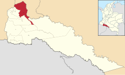
Location of the town and municipality of Mocoa in Putumayo Department.
 Colombia
 Putumayo
 (2018 census)[1]
Mocoa (Spanish pronunciation: [moˈko.a]) (Kamsá: Shatjok[2]) is a municipality and capital city of the department of Putumayo in Colombia.
The city is located in the northwest of the Putumayo department. The municipality borders the departments of Nariño to the west and Cauca to the north.
On March 31, 2017, mudslides in Mocoa left more than 254[3] people dead, and hundreds missing.[4]
Climate
| Climate data for Mocoa (Mocoa Acueducto), elevation 650 m (2,130 ft), (1981–2010) | |||||||||||||
|---|---|---|---|---|---|---|---|---|---|---|---|---|---|
| Month | Jan | Feb | Mar | Apr | May | Jun | Jul | Aug | Sep | Oct | Nov | Dec | Year |
| Mean daily maximum °C (°F) | 27.5 (81.5) | 27.6 (81.7) | 27.2 (81.0) | 27.2 (81.0) | 26.5 (79.7) | 25.8 (78.4) | 26.1 (79.0) | 26.7 (80.1) | 27.7 (81.9) | 28.3 (82.9) | 28.1 (82.6) | 27.9 (82.2) | 27.2 (81.0) |
| Daily mean °C (°F) | 23.4 (74.1) | 23.4 (74.1) | 23.2 (73.8) | 23.0 (73.4) | 22.6 (72.7) | 22.0 (71.6) | 21.9 (71.4) | 22.3 (72.1) | 23.0 (73.4) | 23.3 (73.9) | 23.4 (74.1) | 23.4 (74.1) | 22.9 (73.2) |
| Mean daily minimum °C (°F) | 20.3 (68.5) | 20.5 (68.9) | 20.4 (68.7) | 20.4 (68.7) | 20.2 (68.4) | 19.7 (67.5) | 19.3 (66.7) | 19.4 (66.9) | 19.8 (67.6) | 20.3 (68.5) | 20.5 (68.9) | 20.6 (69.1) | 20.1 (68.2) |
| Average precipitation mm (inches) | 200.6 (7.90) | 227.1 (8.94) | 273.1 (10.75) | 383.5 (15.10) | 442.3 (17.41) | 473.5 (18.64) | 411.3 (16.19) | 348.0 (13.70) | 296.3 (11.67) | 237.2 (9.34) | 236.0 (9.29) | 214.8 (8.46) | 3,656.3 (143.95) |
| Average precipitation days | 19 | 19 | 23 | 24 | 26 | 26 | 25 | 23 | 20 | 21 | 20 | 21 | 260 |
| Average relative humidity (%) | 85 | 84 | 86 | 86 | 87 | 88 | 87 | 84 | 82 | 82 | 83 | 85 | 85 |
| Mean monthly sunshine hours | 99.2 | 84.7 | 80.6 | 81.0 | 74.4 | 66.0 | 74.4 | 93.0 | 108.0 | 117.8 | 108.0 | 111.6 | 1,098.7 |
| Mean daily sunshine hours | 3.2 | 3.0 | 2.6 | 2.7 | 2.4 | 2.2 | 2.4 | 3.0 | 3.6 | 3.8 | 3.6 | 3.6 | 3.0 |
| Source: Instituto de Hidrologia Meteorologia y Estudios Ambientales[5] | |||||||||||||
References
- ^ Citypopulation.de Population of Mocoa municipality with localities
- ^ O'Brien, Colleen Alena (2018). A Grammatical Description of Kamsá, A Language Isolate of Colombia (PDF).
- ^ Brodzinsky, Sibylla (2017-04-02). "Colombia landslide leaves at least 254 dead and hundreds missing". The Guardian. ISSN 0261-3077. Retrieved 2017-04-03.
- ^ Brocchetto, Marilia; Ramos, Fernando; Sanchez, Ray. "Mudslides kill more than 200 people in Colombia". CNN. Retrieved 1 April 2017.
- ^ "Promedios Climatológicos 1981–2010" (in Spanish). Instituto de Hidrologia Meteorologia y Estudios Ambientales. Archived from the original on 15 August 2016. Retrieved 17 June 2024.
External links
- (in Spanish) Mocoa official website
- (in Spanish) Mocoa official website 2
- (in Spanish) Territorial-Environmental Information System of Colombian Amazon SIAT-AC website

| Authority control databases |
|
|---|
 | This Department of Putumayo location article is a stub. You can help Wikipedia by expanding it. |
- v
- t
- e


