Hausen am Tann
Town in Baden-Württemberg, Germany
Municipality in Baden-Württemberg, Germany

Coat of arms
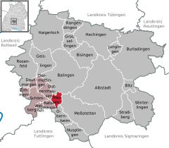
Location of Hausen am Tann within Zollernalbkreis district
48°11′54″N 08°50′12″E / 48.19833°N 8.83667°E / 48.19833; 8.83667
(2022-12-31)[1]
72361
Hausen am Tann is a town in the Zollernalbkreis district of Baden-Württemberg, Germany.
History
In 1805 Hausen am Tann, formerly a possession of Austria, became part of the Kingdom of Württemberg, whose government assigned it to Oberamt Balingen [de]. In 1810, it was reassigned to Oberamt Spaichingen [de] and in 1842 to Oberamt Rottweil [de]. In 1938, that district was merged into the new Landkreis Balingen [de]. There was modest development in Hausen after World War II in the 1950s. In 1973, as part of that year's reform of Baden-Württemberg's districts [de], Balingen's district and by extension Hausen were merged into a new district, Zollernalbkreis. There was some additional development to the north and southwest in the late 1990s.[2]
Geography
The municipality (Gemeinde) of Hausen am Tann covers 8.49 square kilometers (3.28 sq mi) of the Zollernalb district of Baden-Württemberg, a state of the Federal Republic of Germany. It is physically located in the western foothills of the Swabian Jura [de]. Elevation above sea level in the municipality ranges from a high of 995 meters (3,264 ft) Normalnull (NN) at the top of the Schafberg to a low of 697 meters (2,287 ft) NN in the valley of the Schlichem.[2]
A portion of the Federally-protected Schafberg-Lochenstein [de] nature reserve is located inside Hausen's municipal area.[2]
Coat of arms
Hausen's coat of arms displays two white foothold trap jaws upon a field of blue. It was adapted from the arms of Dietrich Spät [de], who was lord of the village until his death in 1530. This pattern was awarded by the provisional Württemberg-Hohenzollern government on 13 February 1950. A flag was issued by the Zollernalb district office on 31 March 1982.[2]
Transportation
Hausen is only connected to Germany's roadways by the K7170. Local public transportation is provided by the Verkehrsverbund Neckar-Alb-Donau [de].[2]
Citations
Wikimedia Commons has media related to Hausen am Tann.
- ^ "Bevölkerung nach Nationalität und Geschlecht am 31. Dezember 2022" [Population by nationality and sex as of December 31, 2022] (CSV) (in German). Statistisches Landesamt Baden-Württemberg. June 2023.
- ^ a b c d e "Hausen am Tann". LEO-BW (in German). Baden-Württemberg. Retrieved 16 July 2020.

Authority control databases | |
|---|---|
| International |
|
| National |
|


