Grade I listed buildings in the Vale of Glamorgan

Map all coordinates using OpenStreetMap
Download coordinates as:
- KML
- GPX (all coordinates)
- GPX (primary coordinates)
- GPX (secondary coordinates)
There are 33 Grade I listed buildings in the Vale of Glamorgan all of which are churches and priory buildings, castles, country or manor houses and associated structures such as churchyard crosses and a dovecote.[1]
The Vale of Glamorgan is a county borough in Wales. In the United Kingdom, the term listed building refers to a building or other structure officially designated as being of special architectural, historical, or cultural significance; Grade I structures are those considered to be "buildings of exceptional interest".[2] Listing was begun by a provision in the Town and Country Planning Act 1947. Once listed, strict limitations are imposed on the modifications allowed to a building's structure or fittings. In Wales,[3] the authority for listing under the Planning (Listed Buildings and Conservation Areas) Act 1990[4] rests with Cadw.
Buildings
| Name | Location Grid Ref.[note 1] Geo-coordinates | Date Listed | Function | Notes | Reference Number | Image |
|---|---|---|---|---|---|---|
| Ewenny Priory Church | Ewenny SS9125777813 51°29′20″N 3°34′03″W / 51.488796966353°N 3.5676241603519°W / 51.488796966353; -3.5676241603519 (Ewenny Priory Church) | 26 July 1963 | Church | The E part of the surviving Priory complex, on the S bank of the Ewenny River, NE of Ewenny village and due N of Corntown, bordered by Ewenny Priory (house) gardens to S and churchyard N.[5][6] | 11250 |  See more images |
| Church of St Michael | Ewenny Priory SS9124277808 51°29′19″N 3°34′04″W / 51.488749135387°N 3.5678385766295°W / 51.488749135387; -3.5678385766295 (Church of St Michael) | 26 July 1963 | Church | The W part of the surviving Priory church, on the E side of the Priory complex, on S bank of Ewenny River, NE of Ewenny Village and N of Corntown.[7][8] | 11251 |  See more images |
| Llanmihangel Place | Llandow SS9811571947 51°26′14″N 3°28′02″W / 51.437349898281°N 3.467191921422°W / 51.437349898281; -3.467191921422 (Llanmihangel Place) | 16 December 1952 | Manor House | Located to the north of the Parish Church, approximately three miles south of Cowbridge.[9][10] | 13136 |  See more images |
| Llansannor Court | Llansannor SS9935077460 51°29′14″N 3°27′04″W / 51.487125383977°N 3.4510016067522°W / 51.487125383977; -3.4510016067522 (Llansannor Court) | 16 December 1952 | House | In the centre of Llansannor village beside the Church of St. Senwyr.[11][12] | 13137 |  See more images |
| Nash Manor | Llandow SS9623872932 51°26′45″N 3°29′40″W / 51.445862204951°N 3.4944751685214°W / 51.445862204951; -3.4944751685214 (Nash Manor) | 16 December 1952 | Manor House | A multi-period country house 1km south of Llysworney[13][14] | 13138 |  Upload Photo |
| Church of St John the Baptist | Llanblethian SS9850174028 51°27′22″N 3°27′44″W / 51.456124604077°N 3.4622381167762°W / 51.456124604077; -3.4622381167762 (Church of St John the Baptist) | 22 February 1963 | Church | To N and above village in large churchyard.[15][16] | 13144 |  See more images |
| Church of St Michael and All Angels | Colwinston SS9396475396 51°28′03″N 3°31′41″W / 51.467587°N 3.527924°W / 51.467587; -3.527924 (Church of St Michael and All Angels) | 22 February 1963 | Church | At the west end of Colwinston village.[17][18] | 13161 |  See more images |
| Church of St Senwyr | Llansannor SS9936777509 51°29′15″N 3°27′03″W / 51.487568855936°N 3.4507708326178°W / 51.487568855936; -3.4507708326178 (Church of St Senwyr) | 22 February 1963 | Church | In the centre of Llansannor village about 4 km north of Cowbridge.[19][20] | 13162 |  See more images |
| St Tathan's Church | St Athan ST0170168003 51°24′09″N 3°24′52″W / 51.402532779197°N 3.414523006149°W / 51.402532779197; -3.414523006149 (St Tathan's Church) | 22 February 1963 | Church | In the centre of St Athan village.[21][22] | 13166 |  See more images |
| Old Beaupre Castle | Llanfair ST0090672024 51°26′19″N 3°25′37″W / 51.438538076987°N 3.4270735749451°W / 51.438538076987; -3.4270735749451 (Old Beaupre Castle) | 22 February 1963 | Castle | Located approximately 2km SW of St Hilary on the E bank of the river Thaw, set on a platformed site, with pedestrian access from St Hilary to St Mary Church road to NW, opposite Howe Mill Farm.[23][24] | 13171 |  See more images |
| Dovecote at Cadoxton Court | Barry ST1276968808 51°24′42″N 3°15′20″W / 51.411582956716°N 3.2556532668365°W / 51.411582956716; -3.2556532668365 (Dovecote at Cadoxton Court) | 18 September 1962 | Dovecote | The largest and best preserved of the medieval dovecots in Glamorgan.[25][26] | 13176 |  See more images |
| Church of the Holy Cross | Cowbridge SS9939574594 51°27′41″N 3°26′58″W / 51.461372°N 3.449537°W / 51.461372; -3.449537 (Church of the Holy Cross) | 5 December 1963 | Church | To NE of town gate and grammar school.[27][28] | 13187 | 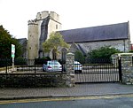 See more images |
| St Illtyd's Church | Llantwit Major SS9662368719 51°24′29″N 3°29′16″W / 51.408064°N 3.487706°W / 51.408064; -3.487706 (St Illtyd's Church) | 22 February 1963 | Church | In the centre of Llantwit Major, west of The Square and well below it.[29][30] | 13259 |  See more images |
| Church of the Holy Trinity | Marcross, St Donats SS9209469063 51°24′37″N 3°33′10″W / 51.410311°N 3.552902°W / 51.410311; -3.552902 (Church of the Holy Trinity) | 22 February 1963 | Church | In the centre of Marcross village.[31][32] | 13303 |  See more images |
| St Donat's Castle, including entrance bridge | St Donats SS9343268108 51°24′07″N 3°32′00″W / 51.401980375972°N 3.5333843092096°W / 51.401980375972; -3.5333843092096 (St Donat's Castle, including entrance bridge) | 16 December 1952 | Castle | The castle stands on a rocky outcrop overlooking the Bristol Channel with the terraced gardens descending to the sea on the south side. The village was originally at the gate and round the church but it was moved away in the C19.[33][34] | 13325 |  See more images |
| Walls, steps, terraces, pavilion, summerhouses and cottage attached to wall of the Hanging Gardens at St Donat's Castle | St Donats SS9344768021 51°24′04″N 3°31′59″W / 51.40120121049°N 3.5331426008808°W / 51.40120121049; -3.5331426008808 (Walls, steps, terraces, pavilion, summerhouses and cottage attached to wall of the Hanging Gardens at St Donat's Castle) | 22 February 1963 | Terracing | Stepping down in tiers from the main south front of St Donats Castle towards the sea.[35][36] | 13326 | Upload Photo |
| Church of St Donat | St Donats SS9336468066 51°24′06″N 3°32′04″W / 51.401590°N 3.534349°W / 51.401590; -3.534349 (Church of St Donat) | 22 February 1963 | Church | In the bottom of the cwm below the west side of the castle.[37][38] | 13329 | 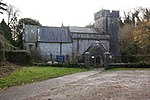 See more images |
| Medieval Cross and associated Slab in the Churchyard of the Church of St Donat | St Donats SS9336868052 51°24′05″N 3°32′03″W / 51.401465°N 3.534287°W / 51.401465; -3.534287 (Medieval Cross and associated Slab in the Churchyard of the Church of St Donat) | 22 February 1963 | About 10m from the south side of the church.[39][40] | 13330 |  | |
| St Augustine's Church | Penarth ST1884072040 51°26′30″N 3°10′09″W / 51.441540869179°N 3.1691225158235°W / 51.441540869179; -3.1691225158235 (St Augustine's Church) | 4 April 1989 | Church | In walled churchyard on highest part of Penarth Head; entrance close to junction with St Augustine's Place.[41][42] | 13347 | 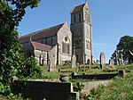 See more images |
| Hensol Castle (including attached courtyard ranges to the north) | Pendoylan ST0474078949 51°30′05″N 3°22′26″W / 51.501445277206°N 3.3737995799247°W / 51.501445277206; -3.3737995799247 (Hensol Castle (including attached courtyard ranges to the north)) | 5 February 1993 | Castle | Country house set within a landscaped park with lake and tree lined drive.[43][44] | 13482 |  See more images |
| Fonmon Castle | Rhoose ST0473868097 51°24′14″N 3°22′15″W / 51.403896943357°N 3.3709025378391°W / 51.403896943357; -3.3709025378391 (Fonmon Castle) | 14 February 1952 | Castle | On the north side of the B4265 but approached via a drive from Fonmon village.[45][46] | 13597 | 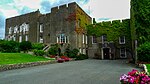 See more images |
| Castle Farmhouse | St Georges-super-Ely ST0986776785 51°28′58″N 3°17′58″W / 51.482835237284°N 3.2994030383844°W / 51.482835237284; -3.2994030383844 (Castle Farmhouse) | 14 February 1952 | Farmhouse | In the centre of the small hamlet of St Georges, which is about 0.5 m from the church; the River Ely runs along the N side.[47][48] | 13600 |  See more images |
| St Cadoc's Church | Llancarfan ST0512470198 51°25′22″N 3°21′57″W / 51.422848°N 3.365918°W / 51.422848; -3.365918 (St Cadoc's Church) | 28 January 1963 | Church | Parish church with many surviving medieval features located at centre of the village.[49][50] | 13605 |  See more images |
| Church of St Michael | Michaelston-le-Pit ST1518072981 51°26′58″N 3°13′19″W / 51.449462°N 3.221996°W / 51.449462; -3.221996 (Church of St Michael) | 28 January 1963 | Church | In the centre of the village, on a steep rise, the churchyard sloping to south.[51][52] | 13612 |  See more images |
| Church of St Donat | Welsh St Donats ST0279076266 51°28′37″N 3°24′04″W / 51.476996°N 3.401144°W / 51.476996; -3.401144 (Church of St Donat) | 28 January 1963 | Church | In the centre of Welsh St Donats village.[53][54] | 13641 | 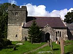 See more images |
| Coedarhydyglyn including attached outbuildings at rear | St Georges Super Ely ST1043275137 51°28′05″N 3°17′27″W / 51.468110959673°N 3.2908503453194°W / 51.468110959673; -3.2908503453194 (Coedarhydyglyn including attached outbuildings at rear) | 13 September 1994 | House | In an elevated position overlooking surrounding parkland and the Vale of Glamorgan beyond; reached by a long drive from the lane to Drope and St Georges which leads off the A48 at Tumbledown.[55][56] | 14864 |  See more images |
| West Precinct Wall at Ewenny Priory (house) | Ewenny SS9112177726 51°29′17″N 3°34′10″W / 51.487988780915°N 3.5695553208377°W / 51.487988780915; -3.5695553208377 (West Precinct Wall at Ewenny Priory (house)) | 3 March 1998 | Wall | West of Ewenny Priory and just south of Ewenny River, bordering the lane and now enclosing part of Ewenny Priory (house) garden.[57][58] | 19460 |  See more images |
| North Gatehouse at Ewenny Priory (house) | Ewenny SS9114877809 51°29′19″N 3°34′09″W / 51.488740000747°N 3.5691922216155°W / 51.488740000747; -3.5691922216155 (North Gatehouse at Ewenny Priory (house)) | 3 March 1998 | Gatehouse | Facing Abbey Road and Ewenny River, within the Priory complex on NW side.[59] | 19462 |  See more images |
| Romanesque gateway in former E precinct wall at Ewenny Priory (house) | Ewenny SS9129377793 51°29′19″N 3°34′02″W / 51.48862413988°N 3.5670996953184°W / 51.48862413988; -3.5670996953184 (Romanesque gateway in former E precinct wall at Ewenny Priory (house)) | 3 March 1998 | Gateway | Set in stretch of original medieval precinct wall on E side of Ewenny Priory (house) garden.[60][61] | 19466 | Upload Photo |
| North tower and attached stretch of precinct wall at Ewenny Priory (house) | Ewenny SS9119677834 51°29′20″N 3°34′07″W / 51.488973959212°N 3.5685088695422°W / 51.488973959212; -3.5685088695422 (North tower and attached stretch of precinct wall at Ewenny Priory (house)) | 3 March 1998 | Tower | On the north side of the Priory complex, facing Abbey Road and Ewenny River, close to the Priory churchyard and backing onto the Stable Court of Ewenny Priory house.[62][63] | 19470 |  See more images |
| South Gatehouse at Ewenny Priory (house) | Ewenny SS9117577712 51°29′16″N 3°34′08″W / 51.487873362752°N 3.5687735652249°W / 51.487873362752; -3.5687735652249 (South Gatehouse at Ewenny Priory (house)) | 3 March 1998 | Gatehouse | At the S boundary of Ewenny Priory garden adjoining the parkland S and the precinct wall W.[64][65] | 19471 |  See more images |
| Ogmore Castle | St Brides Major SS8819176969 51°28′50″N 3°36′41″W / 51.480612067096°N 3.6114977626924°W / 51.480612067096; -3.6114977626924 (Ogmore Castle) | 3 March 1999 | Castle | Located on the SE side of the River Ewenny, just before it joins the Ogmore River, in the hamlet of Ogmore to the NW of the B4524. A series of stepping stones cross the river at this point.[66][67] | 21793 |  See more images |
| Churchyard Cross at Church of St Canna | Llangan SS9575277814 51°29′23″N 3°30′10″W / 51.489654°N 3.502907°W / 51.489654; -3.502907 (Churchyard Cross at Church of St Canna) | 22 July 2003 | Churchyard Cross | In the churchyard beside the main path.[68][69] | 81314 |  See more images |
Notes
- ^ Sometimes known as OSGB36, the grid reference is based on the British national grid reference system used by the Ordnance Survey.
See also
 Wales portal

- Grade II* listed buildings in the Vale of Glamorgan
- Listed buildings in the Vale of Glamorgan
- List of scheduled monuments in the Vale of Glamorgan
- Registered historic parks and gardens in the Vale of Glamorgan
References
- ^ British Listed Buildings online. "Grade I Listed Buildings in the Vale of Glamorgan". www.britishlistedbuildings.co.uk. Retrieved 4 April 2019.
- ^ "Buildings & Conservation Areas". Cadw. Retrieved 18 June 2013.
- ^ "Coflein". online database of RCAHMW. Royal Commission on the Ancient and Historical Monuments of Wales. Retrieved 28 November 2016.
- ^ "Planning (Listed Buildings and Conservation Areas) Act 1990". The National Archives. Retrieved 18 June 2013.
- ^ Cadw. "Ewenny Priory (11250)". National Historic Assets of Wales.
- ^ "Ewenny Priory Church". British Listed Buildings. Retrieved 4 April 2019.
- ^ Cadw. "Church of St Michael (11251)". National Historic Assets of Wales.
- ^ "Church of St Michael". British Listed Buildings. Retrieved 4 April 2019.
- ^ Cadw. "Llanmihangel Place (13136)". National Historic Assets of Wales.
- ^ "Llanmihangel Place". British Listed Buildings. Retrieved 4 April 2019.
- ^ Cadw. "Llansannor Court (13137)". National Historic Assets of Wales.
- ^ "Llansannor Court". British Listed Buildings. Retrieved 4 April 2019.
- ^ Cadw. "Ewenny Priory (13138)". National Historic Assets of Wales.
- ^ "Nash Manor". British Listed Buildings. Retrieved 4 April 2019.
- ^ Cadw. "Church of St John the Baptist (13144)". National Historic Assets of Wales. Retrieved 5 April 2019.
- ^ "Church of St John the Baptist". British Listed Buildings. Retrieved 4 April 2019.
- ^ Cadw. "Church of St Michael and All Angels (13161)". National Historic Assets of Wales.
- ^ "Church of St Michael and All Angels". British Listed Buildings. Retrieved 4 April 2019.
- ^ Cadw. "Church of St. Senwyr (13162)". National Historic Assets of Wales. Retrieved 5 April 2019.
- ^ "Church of St. Senwyr". British Listed Buildings. Retrieved 4 April 2019.
- ^ Cadw. "Church of St Athan (13166)". National Historic Assets of Wales. Retrieved 5 April 2019.
- ^ "Church of St Athan". British Listed Buildings. Retrieved 4 April 2019.
- ^ Cadw. "Old Beaupre Castle (13171)". National Historic Assets of Wales. Retrieved 5 April 2019.
- ^ "Old Beaupre Castle". British Listed Buildings. Retrieved 4 April 2019.
- ^ Cadw. "Dovecote at Cadoxton Court (13176)". National Historic Assets of Wales. Retrieved 5 April 2019.
- ^ "Dovecote at Cadoxton Court". British Listed Buildings. Retrieved 4 April 2019.
- ^ Cadw. "Church of the Holy Cross (13187)". National Historic Assets of Wales. Retrieved 5 April 2019.
- ^ "Church of the Holy Cross". British Listed Buildings. Retrieved 4 April 2019.
- ^ Cadw. "Church of St Illtud (13259)". National Historic Assets of Wales. Retrieved 6 April 2019.
- ^ "Church of St Illtud". British Listed Buildings. Retrieved 6 April 2019.
- ^ Cadw. "Church of the Holy Trinity (13303)". National Historic Assets of Wales. Retrieved 6 April 2019.
- ^ "Church of the Holy Trinity". British Listed Buildings. Retrieved 6 April 2019.
- ^ Cadw. "St Donats Castle (United World College of the (Atlantic), including entrance Bridge (13325)". National Historic Assets of Wales. Retrieved 6 April 2019.
- ^ "St Donats Castle (United World College of the (Atlantic), including entrance Bridge". British Listed Buildings. Retrieved 6 April 2019.
- ^ Cadw. "Walls, Steps, Terraces, Pavilion, Summerhouses and Cottage attached to wall of the Hanging Gardens (13326)". National Historic Assets of Wales. Retrieved 6 April 2019.
- ^ "Walls, Steps, Terraces, Pavilion, Summerhouses and Cottage attached to wall of the Hanging Gardens". British Listed Buildings. Retrieved 6 April 2019.
- ^ Cadw. "Church of St Donat (13329)". National Historic Assets of Wales. Retrieved 6 April 2019.
- ^ "Church of St Donat". British Listed Buildings. Retrieved 6 April 2019.
- ^ Cadw. "Medieval Cross and associated Slab in the Churchyard of the Church of St Donat (13330)". National Historic Assets of Wales. Retrieved 6 April 2019.
- ^ "Medieval Cross and associated Slab in the Churchyard of the Church of St Donat". British Listed Buildings. Retrieved 6 April 2019.
- ^ Cadw. "St Augustine's Parish Church (13347)". National Historic Assets of Wales. Retrieved 6 April 2019.
- ^ "St Augustine's Parish Church". British Listed Buildings. Retrieved 6 April 2019.
- ^ Cadw. "Hensol Castle (Including attached Courtyard Ranges to N) (13482)". National Historic Assets of Wales. Retrieved 6 April 2019.
- ^ "Hensol Castle (Including attached Courtyard Ranges to N)". British Listed Buildings. Retrieved 6 April 2019.
- ^ Cadw. "Fonmon Castle (13597)". National Historic Assets of Wales. Retrieved 6 April 2019.
- ^ "Fonmon Castle". British Listed Buildings. Retrieved 6 April 2019.
- ^ Cadw. "Castle Farmhouse (13600)". National Historic Assets of Wales. Retrieved 6 April 2019.
- ^ "Castle Farmhouse". British Listed Buildings. Retrieved 6 April 2019.
- ^ Cadw. "St Cadoc's Parish Church (13605)". National Historic Assets of Wales. Retrieved 6 April 2019.
- ^ "St Cadoc's Parish Church". British Listed Buildings. Retrieved 6 April 2019.
- ^ Cadw. "Church of St Michael (13612)". National Historic Assets of Wales. Retrieved 6 April 2019.
- ^ "Church of St Michael". British Listed Buildings. Retrieved 6 April 2019.
- ^ Cadw. "Church of St Donat (13641)". National Historic Assets of Wales. Retrieved 6 April 2019.
- ^ "Church of St Donat". British Listed Buildings. Retrieved 6 April 2019.
- ^ Cadw. "Coedarhydyglyn including attached outbuildings at rear (14864)". National Historic Assets of Wales. Retrieved 6 April 2019.
- ^ "Coedarhydyglyn including attached outbuildings at rear". British Listed Buildings. Retrieved 6 April 2019.
- ^ Cadw. "W Precinct Wall at Ewenny Priory (house) (19460)". National Historic Assets of Wales. Retrieved 6 April 2019.
- ^ "W Precinct Wall at Ewenny Priory (house)". British Listed Buildings. Retrieved 6 April 2019.
- ^ Cadw. "N Gatehouse at Ewenny Priory (house) (19462)". National Historic Assets of Wales. Retrieved 6 April 2019.
- ^ Cadw. "Romanesque gateway in former E precinct wall at Ewenny Priory (house) (19466)". National Historic Assets of Wales. Retrieved 5 April 2019.
- ^ "Romanesque gateway in former E precinct wall at Ewenny Priory (house)". British Listed Buildings. Retrieved 4 April 2019.
- ^ Cadw. "N tower and attached stretch of precinct wall at Ewenny Priory (house) (19470)". National Historic Assets of Wales. Retrieved 5 April 2019.
- ^ "N tower and attached stretch of precinct wall at Ewenny Priory (house)". British Listed Buildings. Retrieved 4 April 2019.
- ^ Cadw. "S Gatehouse at Ewenny Priory (house) (19471)". National Historic Assets of Wales. Retrieved 5 April 2019.
- ^ "S Gatehouse at Ewenny Priory (house)". British Listed Buildings. Retrieved 4 April 2019.
- ^ Cadw. "Ogmore Castle (21793)". National Historic Assets of Wales. Retrieved 5 April 2019.
- ^ "Ogmore Castle". British Listed Buildings. Retrieved 4 April 2019.
- ^ Cadw. "Churchyard Cross at Church of St Canna (81214)". National Historic Assets of Wales. Retrieved 5 April 2019.
- ^ "Churchyard Cross at Church of St Canna". British Listed Buildings. Retrieved 4 April 2019.
External links
![]() Media related to Grade I listed buildings in the Vale of Glamorgan at Wikimedia Commons
Media related to Grade I listed buildings in the Vale of Glamorgan at Wikimedia Commons
- v
- t
- e
 Architecture
 Wales
Wales


