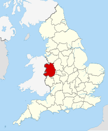
Grade I listed buildings in Shropshire
Map all coordinates using OpenStreetMap
Download coordinates as:
- KML
- GPX (all coordinates)
- GPX (primary coordinates)
- GPX (secondary coordinates)
There are over 9000 Grade I listed buildings in England. The following is a selected list of these buildings in the county of Shropshire, organised by district.
Shropshire
| Name | Location | Type | Completed [note 1] | Date designated | Grid ref.[note 2] Geo-coordinates | Entry number [note 3] | Image |
|---|---|---|---|---|---|---|---|
| Church of the Holy Trinity | Holdgate, Abdon | Church | 12th century | 12 November 1954 | SO5616589591 52°30′09″N 2°38′50″W / 52.502446°N 2.647193°W / 52.502446; -2.647193 (Church of the Holy Trinity) | 1383399 |  More images |
| Acton Burnell Castle | Acton Burnell | Fortified Manor House | 1284-1285 | 13 June 1958 | SJ5338201898 52°36′46″N 2°41′24″W / 52.612844°N 2.689922°W / 52.612844; -2.689922 (Acton Burnell Castle) | 1366722 |  More images |
| Church of St Mary | Acton Burnell | Parish Church | 1250-1280 | 13 June 1958 | SJ5334901932 52°36′47″N 2°41′25″W / 52.613147°N 2.690414°W / 52.613147; -2.690414 (Church of St Mary) | 1366700 |  More images |
| Acton Round Hall | Acton Round | House | Queen Anne | 29 November 1951 | SO6360895578 52°33′25″N 2°32′18″W / 52.556815°N 2.538208°W / 52.556815; -2.538208 (Acton Round Hall) | 1053221 |  More images |
| Church of Saint Peter | Adderley | Parish Church | 1635-7 | 10 February 1959 | SJ6610539533 52°57′08″N 2°30′21″W / 52.952097°N 2.505939°W / 52.952097; -2.505939 (Church of Saint Peter) | 1055290 |  More images |
| Wattlesborough Castle, Remains Of, Adjoining Wattlesborough to North West | Alberbury with Cardeston | Castle | Late 13th century | 29 January 1952 | SJ3550812621 52°42′27″N 2°57′21″W / 52.707396°N 2.955964°W / 52.707396; -2.955964 (Wattlesborough Castle, Remains Of, Adjoining Wattlesborough to North West) | 1366883 |  More images |
| Attingham Park | Atcham | Country House | 1783-1785 | 29 January 1952 | SJ5498909891 52°41′05″N 2°40′02″W / 52.68483°N 2.667283°W / 52.68483; -2.667283 (Attingham Park) | 1055094 |  More images |
| Church of St Eata | Atcham | Parish Church | 12th century | 13 June 1958 | SJ5409509194 52°40′43″N 2°40′49″W / 52.67849°N 2.68041°W / 52.67849; -2.68041 (Church of St Eata) | 1176664 |  More images |
| Cronkhill | Cronkhill, Atcham | House | 17th century | 29 January 1952 | SJ5357708283 52°40′13″N 2°41′17″W / 52.670256°N 2.687942°W / 52.670256; -2.687942 (Cronkhill) | 1176915 |  More images |
| Longner Hall and Short Section of Forecourt Wall Adjoining to North West | Longner, Atcham | House | 1803 | 29 January 1952 | SJ5287011076 52°41′43″N 2°41′56″W / 52.695301°N 2.698797°W / 52.695301; -2.698797 (Longner Hall and Short Section of Forecourt Wall Adjoining to North West) | 1055105 |  More images |
| Benthall Hall | Benthall, Barrow | House | Late 16th century | 24 October 1950 | SJ6580402609 52°37′13″N 2°30′24″W / 52.620163°N 2.506548°W / 52.620163; -2.506548 (Benthall Hall) | 1176832 |  More images |
| Church of St Giles | Barrow | Church | Developed between C8 and c1100 | 24 October 1950 | SO6579099983 52°35′48″N 2°30′23″W / 52.596556°N 2.506482°W / 52.596556; -2.506482 (Church of St Giles) | 1367837 | 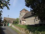 More images |
| Church of St Leonard | Linley, Barrow | Church | Late 12th century | 24 October 1950 | SO6866098505 52°35′00″N 2°27′50″W / 52.583443°N 2.463973°W / 52.583443; -2.463973 (Church of St Leonard) | 1176860 |  More images |
| Church of All Saints | Berrington | Parish Church | 13th century | 13 June 1958 | SJ5304206860 52°39′27″N 2°41′44″W / 52.657419°N 2.69565°W / 52.657419; -2.69565 (Church of All Saints) | 1176997 |  More images |
| Cross in Churchyard of Church of St Mary | Bitterley | Cross | 14th century | 12 November 1954 | SO5708777296 52°23′31″N 2°37′55″W / 52.391994°N 2.632026°W / 52.391994; -2.632026 (Cross in Churchyard of Church of St Mary) | 1383653 |  More images |
| Bishop Percy's House | Bridgnorth | Timber Framed House | 1580 | 18 July 1949 | SO7180893088 52°32′06″N 2°25′01″W / 52.534919°N 2.417051°W / 52.534919; -2.417051 (Bishop Percy's House) | 1367867 |  More images |
| Church of St Mary the Virgin | Bromfield | House | 16th century | 12 November 1954 | SO4819976810 52°23′13″N 2°45′45″W / 52.386855°N 2.762547°W / 52.386855; -2.762547 (Church of St Mary the Virgin) | 1291888 |  More images |
| Abbey House with attached 5 Bay Arcade, incorporating Dovecote | Buildwas | Abbey | 13th century | 24 February 1986 | SJ6436404354 52°38′09″N 2°31′41″W / 52.635756°N 2.528006°W / 52.635756; -2.528006 (Abbey House with attached 5 Bay Arcade, incorporating Dovecote) | 1366862 |  |
| Buildwas Abbey Comprising Guardianship Monument and Part of Claustral Ranges in Grounds of Abbey House | Buildwas | Abbey | 1135 | 13 June 1958 | SJ6432204301 52°38′07″N 2°31′43″W / 52.635277°N 2.528621°W / 52.635277; -2.528621 (Buildwas Abbey Comprising Guardianship Monument and Part of Claustral Ranges in Grounds of Abbey House) | 1175126 |  More images |
| Church of St Mary | Burford | Church | 12th century | 12 November 1954 | SO5832568028 52°18′32″N 2°36′46″W / 52.308774°N 2.612682°W / 52.308774; -2.612682 (Church of St Mary) | 1383422 |  More images |
| Church of St James | Cardington | Parish Church | 12th century | 13 June 1958 | SO5063495149 52°33′07″N 2°43′46″W / 52.551934°N 2.729494°W / 52.551934; -2.729494 (Church of St James) | 1366702 |  More images |
| Plaish Hall | Plaish, Cardington | House | 15th century | 29 January 1952 | SO5301896480 52°33′51″N 2°41′40″W / 52.56411°N 2.694526°W / 52.56411; -2.694526 (Plaish Hall) | 1307552 |  More images |
| Church of St Peter | Chelmarsh | Church | 12th century | 9 March 1970 | SO7205587847 52°29′16″N 2°24′47″W / 52.487817°N 2.412968°W / 52.487817; -2.412968 (Church of St Peter) | 1188126 |  More images |
| Church of St Michael | Chirbury, Chirbury with Brompton | Church | Late C12-1536 | 21 March 1968 | SO2613198513 52°34′46″N 3°05′30″W / 52.579391°N 3.091562°W / 52.579391; -3.091562 (Church of St Michael) | 1055048 |  More images |
| Remains of Compound Pier approx. 20 Metres North East of Chancel of Church of St Michael | Chirbury, Chirbury with Brompton | Structure | Late 13th century | 21 March 1968 | SO2615298546 52°34′47″N 3°05′29″W / 52.579691°N 3.09126°W / 52.579691; -3.09126 (Remains of Compound Pier approx. 20 Metres North East of Chancel of Church of St Michael) | 1055050 |  Upload Photo |
| Church of St Lawrence | Church Stretton | Church | 12th century | 4 July 1952 | SO4523993675 52°32′17″N 2°48′32″W / 52.538167°N 2.808809°W / 52.538167; -2.808809 (Church of St Lawrence) | 1383267 |  More images |
| Church of All Saints | Claverley | Church | Norman | 9 March 1970 | SO7926493425 52°32′18″N 2°18′26″W / 52.538285°N 2.307154°W / 52.538285; -2.307154 (Church of All Saints) | 1188258 |  More images |
| Ludstone Hall | Claverley | Moated house | c. 1607 | 29 November 1951 | SO7999994483 52°32′52″N 2°17′47″W / 52.547824°N 2.296382°W / 52.547824; -2.296382 (Ludstone Hall) | 1053874 | 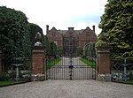 More images |
| Church of St Mary | Cleobury Mortimer | Church | 12th century | 12 November 1954 | SO6740075791 52°22′45″N 2°28′49″W / 52.379178°N 2.480338°W / 52.379178; -2.480338 (Church of St Mary) | 1383457 |  More images |
| Mawley Hall | Cleobury Mortimer | Country House | c. 1730 | 12 November 1954 | SO6886075258 52°22′28″N 2°27′32″W / 52.374472°N 2.458841°W / 52.374472; -2.458841 (Mawley Hall) | 1383432 |  More images |
| Remains of Clun Castle | Clun | Castle | 1090-1110 | 1 December 1951 | SO2983880978 52°25′20″N 3°01′59″W / 52.422271°N 3.033163°W / 52.422271; -3.033163 (Remains of Clun Castle) | 1295475 |  More images |
| Church of St Swithun | Clunbury | Church | 18th century | 21 March 1968 | SO3709480657 52°25′13″N 2°55′35″W / 52.420269°N 2.926419°W / 52.420269; -2.926419 (Church of St Swithun) | 1367001 |  More images |
| Condover Hall | Condover | Country House | 1598 | 3 November 1955 | SJ4952105658 52°38′47″N 2°44′51″W / 52.646297°N 2.747515°W / 52.646297; -2.747515 (Condover Hall) | 1055706 |  More images |
| Main Gateway and Gates to Condover Hall | Condover | Gate | c. 1598 | 10 March 1986 | SJ4962605740 52°38′49″N 2°44′46″W / 52.647044°N 2.745975°W / 52.647044; -2.745975 (Main Gateway and Gates to Condover Hall) | 1055707 |  More images |
| Church of St Peter | Cound | Parish Church | 13th century | 13 June 1958 | SJ5582304996 52°38′27″N 2°39′15″W / 52.640897°N 2.654289°W / 52.640897; -2.654289 (Church of St Peter) | 1055560 |  More images |
| Cound Hall | Cound | Country House | 1704 | 13 June 1958 | SJ5607405329 52°38′38″N 2°39′02″W / 52.643911°N 2.650625°W / 52.643911; -2.650625 (Cound Hall) | 1177385 |  More images |
| Church of St John the Baptist | Stokesay, Craven Arms | Church | 19th century | 12 November 1954 | SO4358681741 52°25′51″N 2°49′52″W / 52.430723°N 2.831153°W / 52.430723; -2.831153 (Church of St John the Baptist) | 1269934 |  More images |
| Stokesay Castle and Gatehouse Including Moat Retaining Walls | Stokesay, Craven Arms | Cross Wing House | c1391-1400 | 12 November 1954 | SO4356181695 52°25′49″N 2°49′53″W / 52.430307°N 2.831513°W / 52.430307; -2.831513 (Stokesay Castle and Gatehouse Including Moat Retaining Walls) | 1269939 |  More images |
| Church of St Edith | Eaton-under-Heywood | Church | 12th century | 12 November 1954 | SO4998690006 52°30′20″N 2°44′18″W / 52.505643°N 2.738274°W / 52.505643; -2.738274 (Church of St Edith) | 1383306 | 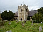 More images |
| Church of St Mary | Ellesmere | Church | Norman | 19 March 1951 | SJ4028034826 52°54′27″N 2°53′22″W / 52.907531°N 2.88941°W / 52.907531; -2.88941 (Church of St Mary) | 1055505 |  More images |
| Church of Saint Andrew | Great Ness | Parish Church | 13th century | 27 May 1953 | SJ3976119033 52°45′56″N 2°53′39″W / 52.76552°N 2.894205°W / 52.76552; -2.894205 (Church of Saint Andrew) | 1295352 |  More images |
| Heath Chapel | Heath | Church | 12th century | 12 November 1954 | SO5573085621 52°28′00″N 2°39′11″W / 52.466723°N 2.653071°W / 52.466723; -2.653071 (Heath Chapel) | 1383722 |  More images |
| Church of St Luke | Hodnet | Church | 1673 | 10 February 1959 | SJ6124128600 52°51′13″N 2°34′37″W / 52.853491°N 2.577023°W / 52.853491; -2.577023 (Church of St Luke) | 1366827 |  More images |
| Hawkestone Hall | Hodnet | Country House | c. 1700 | 10 February 1959 | SJ5813829930 52°51′55″N 2°37′24″W / 52.865213°N 2.623272°W / 52.865213; -2.623272 (Hawkestone Hall) | 1055335 |  More images |
| Church of St John the Baptist | Hope Bagot | Church | 12th century | 12 November 1954 | SO5887974060 52°21′47″N 2°36′19″W / 52.363042°N 2.605297°W / 52.363042; -2.605297 (Church of St John the Baptist) | 1383523 | 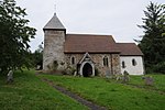 More images |
| Church of St Mary | Hopesay | Church | Mid 19th century | 28 May 1987 | SO3892683279 52°26′39″N 2°54′00″W / 52.444046°N 2.899964°W / 52.444046; -2.899964 (Church of St Mary) | 1054961 | 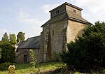 More images |
| Hopton Castle, Remains of | Hopton Castle | Castle | Early 14th century | 1 December 1951 | SO3669777938 52°23′45″N 2°55′54″W / 52.395783°N 2.93174°W / 52.395783; -2.93174 (Hopton Castle, Remains of) | 1054935 |  More images |
| Church of St John the Baptist | Hughley | Parish Church | Late 17th century | 11 June 1958 | SO5648197935 52°34′39″N 2°38′37″W / 52.577478°N 2.643634°W / 52.577478; -2.643634 (Church of St John the Baptist) | 1366851 |  More images |
| Church of St John the Baptist | Kinlet | Church | 12th century | 9 March 1970 | SO7106681032 52°25′35″N 2°25′37″W / 52.4265°N 2.426939°W / 52.4265; -2.426939 (Church of St John the Baptist) | 1053830 |  More images |
| Kinlet Hall (including Office Wings and Stables) | Kinlet | Country House/School | 1729 | 29 November 1951 | SO7083481182 52°25′40″N 2°25′49″W / 52.427836°N 2.430364°W / 52.427836; -2.430364 (Kinlet Hall (including Office Wings and Stables)) | 1053832 |  More images |
| Adcote and Adjoining Forecourt Walls | Little Ness | Country House | 1876-1881 | 2 July 1971 | SJ4184719391 52°46′08″N 2°51′48″W / 52.768967°N 2.863357°W / 52.768967; -2.863357 (Adcote and Adjoining Forecourt Walls) | 1055113 |  More images |
| Church of St Michael | Llanyblodwel | Parish Church | 12th century | 8 October 1959 | SJ2393822891 52°47′54″N 3°07′46″W / 52.798196°N 3.129561°W / 52.798196; -3.129561 (Church of St Michael) | 1307719 |  More images |
| Church of St Mary | Longnor | Parish Church | Early 18th century | 13 June 1958 | SJ4880500492 52°35′59″N 2°45′26″W / 52.599793°N 2.757294°W / 52.599793; -2.757294 (Church of St Mary) | 1055588 |  More images |
| Longnor Hall | Longnor | Country House | 1670 | 29 January 1952 | SJ4859400504 52°36′00″N 2°45′37″W / 52.599881°N 2.760411°W / 52.599881; -2.760411 (Longnor Hall) | 1366693 |  More images |
| Church of St Michael | Loppington | Parish Church | 14th century | 28 October 1960 | SJ4716229276 52°51′30″N 2°47′10″W / 52.858367°N 2.786191°W / 52.858367; -2.786191 (Church of St Michael) | 1056050 |  More images |
| Ludford Bridge | Ludford | Bridge | 15th century | 12 November 1954 | SO5125774210 52°21′50″N 2°43′02″W / 52.363764°N 2.717241°W / 52.363764; -2.717241 (Ludford Bridge) | 1281983 |  More images |
| Broad Gate, including Broadgate Chambers and Attached Railings | Ludlow | House | C16-C18 | 15 April 1954 | SO5120474380 52°21′55″N 2°43′05″W / 52.365287°N 2.718044°W / 52.365287; -2.718044 (Broad Gate, including Broadgate Chambers and Attached Railings) | 1282001 |  More images |
| Castle House Flats | Ludlow | Flats | 1954 | 15 April 1954 | SO5092774627 52°22′03″N 2°43′20″W / 52.367483°N 2.722148°W / 52.367483; -2.722148 (Castle House Flats) | 1202824 |  More images |
| Church of St Laurence and Attached Railings | Ludlow | Parish Church | 13th century | 15 April 1954 | SO5116074712 52°22′06″N 2°43′07″W / 52.368268°N 2.718738°W / 52.368268; -2.718738 (Church of St Laurence and Attached Railings) | 1202794 |  More images |
| Feathers Hotel | Ludlow | Jettied House | Earlier Core | 15 April 1954 | SO5124874753 52°22′07″N 2°43′03″W / 52.368644°N 2.717452°W / 52.368644; -2.717452 (Feathers Hotel) | 1282026 |  More images |
| The Butter Cross | Ludlow | Market Hall | c. 1746 | 15 April 1954 | SO5113674657 52°22′04″N 2°43′09″W / 52.367771°N 2.719083°W / 52.367771; -2.719083 (The Butter Cross) | 1289674 |  More images |
| Ludlow Castle | Ludlow | Bailey | 12th century | 15 April 1954 | SO5085774631 52°22′03″N 2°43′23″W / 52.367512°N 2.723176°W / 52.367512; -2.723176 (Ludlow Castle) | 1291698 |  More images |
| The Guildhall and Adjoining Coachhouse | Ludlow | House | 1954 | 15 April 1954 | SO5100674512 52°21′59″N 2°43′15″W / 52.366456°N 2.720971°W / 52.366456; -2.720971 (The Guildhall and Adjoining Coachhouse) | 1211188 |  More images |
| The Reader's House | Ludlow | Timber Framed House | c. 1616 | 15 April 1954 | SO5119574733 52°22′06″N 2°43′06″W / 52.368459°N 2.718227°W / 52.368459; -2.718227 (The Reader's House) | 1220775 |  More images |
| Church of St Michael and All Angels | Lydbury North | Parish Church | Early 12th century | 21 March 1968 | SO3521186019 52°28′06″N 2°57′19″W / 52.468247°N 2.955145°W / 52.468247; -2.955145 (Church of St Michael and All Angels) | 1054540 |  More images |
| Linley Hall | Linley, More | Country House | 1742-48 | 1 December 1951 | SO3461992893 52°31′48″N 2°57′55″W / 52.529964°N 2.965211°W / 52.529964; -2.965211 (Linley Hall) | 1054588 |  More images |
| Church of St Bartholomew | Moreton Corbet, Moreton Corbet and Lee Brockhurst | Parish Church | 12th century | 28 October 1960 | SJ5611523240 52°48′18″N 2°39′09″W / 52.804917°N 2.652418°W / 52.804917; -2.652418 (Church of St Bartholomew) | 1307235 |  More images |
| Moreton Corbet Castle | Moreton Corbet, Moreton Corbet and Lee Brockhurst | Castle | c. 1200 | 28 October 1960 | SJ5612523131 52°48′14″N 2°39′08″W / 52.803938°N 2.652255°W / 52.803938; -2.652255 (Moreton Corbet Castle) | 1366802 |  More images |
| The Old Manor House (Preston Hall) | Preston Brockhurst, Moreton Corbet and Lee Brockhurst | Country House | c. 1650 | 28 October 1960 | SJ5365124606 52°49′01″N 2°41′21″W / 52.816989°N 2.68916°W / 52.816989; -2.68916 (The Old Manor House (Preston Hall)) | 1178096 |  More images |
| Church of St Gregory | Morville | Church | Early Norman | 9 March 1970 | SO6696093896 52°32′31″N 2°29′19″W / 52.541909°N 2.488601°W / 52.541909; -2.488601 (Church of St Gregory) | 1053840 |  More images |
| Morville Hall | Morville | House | 16th century | 29 November 1951 | SO6684293996 52°32′34″N 2°29′25″W / 52.542801°N 2.490351°W / 52.542801; -2.490351 (Morville Hall) | 1053841 | 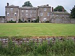 More images |
| Church of Holy Trinity | Much Wenlock | Church | Norman | 24 October 1950 | SO6236699994 52°35′47″N 2°33′25″W / 52.596427°N 2.55703°W / 52.596427; -2.55703 (Church of Holy Trinity) | 1053793 |  More images |
| Priory House | Much Wenlock | House | Dissolution of the Monasteries | 24 October 1950 | SJ6251500022 52°35′48″N 2°33′17″W / 52.596689°N 2.554833°W / 52.596689; -2.554833 (Priory House) | 1053843 | 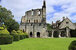 More images |
| Priory of St Milburga (ruins) | Much Wenlock | Chapter House | 12th century | 24 October 1950 | SJ6248600060 52°35′49″N 2°33′19″W / 52.597029°N 2.555266°W / 52.597029; -2.555266 (Priory of St Milburga (ruins)) | 1294473 | 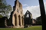 More images |
| Church of St Michael | Munslow | Church | 12th century | 12 November 1954 | SO5211287720 52°29′07″N 2°42′24″W / 52.485285°N 2.706626°W / 52.485285; -2.706626 (Church of St Michael) | 1383331 |  More images |
| Llwyd Mansion | Oswestry | Jettied House | Mid to late 15th century | 10 September 1951 | SJ2907229620 52°51′34″N 3°03′18″W / 52.859376°N 3.054895°W / 52.859376; -3.054895 (Llwyd Mansion) | 1054299 |  More images |
| Church of St Michael | Pitchford | Parish Church | 12th century | 13 June 1958 | SJ5275404286 52°38′03″N 2°41′58″W / 52.634256°N 2.699538°W / 52.634256; -2.699538 (Church of St Michael) | 1177813 |  More images |
| Pitchford Hall | Pitchford | House | 14th century or 15th century | 29 January 1952 | SJ5278204237 52°38′02″N 2°41′57″W / 52.633818°N 2.699117°W / 52.633818; -2.699117 (Pitchford Hall) | 1177907 |  More images |
| Barn Approximately 20m South West of Bank Farmhouse | Pontesbury | Barn | 17th century | 10 March 1986 | SJ3867604016 52°37′50″N 2°54′27″W / 52.630418°N 2.907478°W / 52.630418; -2.907478 (Barn Approximately 20m South West of Bank Farmhouse) | 1366665 | Upload Photo |
| Church of All Saints | Richard's Castle | Parish Church | 1892 | 28 October 1969 | SO4943170658 52°19′54″N 2°44′37″W / 52.331667°N 2.743518°W / 52.331667; -2.743518 (Church of All Saints) | 1383775 |  More images |
| Langley Chapel | Langley, Ruckley and Langley | Chapel | c. 1564 | 13 June 1958 | SJ5383900091 52°35′48″N 2°40′59″W / 52.59664°N 2.68292°W / 52.59664; -2.68292 (Langley Chapel) | 1052167 | 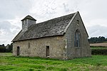 More images |
| Wilderhope Manor | Rushbury | Manor House | Late 16th century | 12 November 1954 | SO5452792879 52°31′55″N 2°40′18″W / 52.531868°N 2.671772°W / 52.531868; -2.671772 (Wilderhope Manor) | 1383384 |  More images |
| Church of St Mary | Selattyn, Selattyn and Gobowen | Parish Church | 13th century | 8 October 1959 | SJ2663934026 52°53′55″N 3°05′31″W / 52.898649°N 3.092018°W / 52.898649; -3.092018 (Church of St Mary) | 1367376 |  More images |
| Church of St Mary the Virgin | Shawbury | Parish Church | Late 12th century | 28 October 1960 | SJ5591821177 52°47′11″N 2°39′18″W / 52.786356°N 2.655061°W / 52.786356; -2.655061 (Church of St Mary the Virgin) | 1055376 | 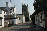 More images |
| Chest Tomb Approximately 1 Metre to South of South Chapel of Church of St Andrew | Shifnal | Chest Tomb | Late 18th century | 29 August 1984 | SJ7470207478 52°39′52″N 2°22′32″W / 52.664422°N 2.375493°W / 52.664422; -2.375493 (Chest Tomb Approximately 1 Metre to South of South Chapel of Church of St Andrew) | 1053624 |  |
| Church of St Andrew | Shifnal | Parish Church | 12th century | 26 May 1955 | SJ7468807491 52°39′52″N 2°22′33″W / 52.664538°N 2.375701°W / 52.664538; -2.375701 (Church of St Andrew) | 1367657 |  More images |
| Shipton Hall | Shipton | House | About 1549 | 29 November 1951 | SO5617491943 52°31′25″N 2°38′51″W / 52.52359°N 2.647371°W / 52.52359; -2.647371 (Shipton Hall) | 1294246 |  More images |
| Abbey Church of the Holy Cross | Shrewsbury | Abbey | Late C11-Early 12th century | 10 January 1953 | SJ4984412474 52°42′27″N 2°44′38″W / 52.707595°N 2.743781°W / 52.707595; -2.743781 (Abbey Church of the Holy Cross) | 1246392 |  More images |
| Church of St Chad | Shrewsbury | Parish Church | 1790-92 | 10 January 1953 | SJ4881912431 52°42′26″N 2°45′32″W / 52.707113°N 2.758944°W / 52.707113; -2.758944 (Church of St Chad) | 1344941 |  More images |
| Church of St Mary | Shrewsbury | Parish Church | 12th century | 10 January 1953 | SJ4933612605 52°42′31″N 2°45′05″W / 52.708726°N 2.75132°W / 52.708726; -2.75132 (Church of St Mary) | 1344964 |  More images |
| Council House Gatehouse and Gateway | Shrewsbury | Timber Framed House | Early 16th century | 10 January 1953 | SJ4941112734 52°42′36″N 2°45′01″W / 52.709892°N 2.75023°W / 52.709892; -2.75023 (Council House Gatehouse and Gateway) | 1247157 |  More images |
| Former Ditherington Flax Mill and attached former Malting Kiln | Ditherington, Shrewsbury | Mill | 1897-1898 | 10 January 1953 | SJ4987413830 52°43′11″N 2°44′37″W / 52.719787°N 2.743545°W / 52.719787; -2.743545 (Former Ditherington Flax Mill and attached former Malting Kiln) | 1270576 | 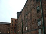 More images |
| Library | Shrewsbury | Library | 1595 | 10 January 1953 | SJ4936512799 52°42′38″N 2°45′03″W / 52.710472°N 2.75092°W / 52.710472; -2.75092 (Library) | 1271288 |  More images |
| Old Market Hall | Shrewsbury | Court House | 1596 | 10 January 1953 | SJ4912412458 52°42′27″N 2°45′16″W / 52.707384°N 2.754434°W / 52.707384; -2.754434 (Old Market Hall) | 1254925 |  More images |
| Refectory Pulpit Approximately 40 Metres South of Abbey House | Shrewsbury | Refectory | 14th century | 10 January 1953 | SJ4985212423 52°42′26″N 2°44′37″W / 52.707138°N 2.743655°W / 52.707138; -2.743655 (Refectory Pulpit Approximately 40 Metres South of Abbey House) | 1246393 |  More images |
| Shrewsbury Castle | Shrewsbury | Bailey | 1164-1300 | 10 January 1953 | SJ4944012881 52°42′40″N 2°44′59″W / 52.711216°N 2.749823°W / 52.711216; -2.749823 (Shrewsbury Castle) | 1246877 |  More images |
| The Abbot's House | Shrewsbury | Jettied House | Late 15th century | 10 January 1953 | SJ4923112535 52°42′29″N 2°45′10″W / 52.708086°N 2.752863°W / 52.708086; -2.752863 (The Abbot's House) | 1246543 |  More images |
| The Lion Hotel | Shrewsbury | Timber Framed House | Late 15th century | 10 January 1953 | SJ4931412340 52°42′23″N 2°45′06″W / 52.706341°N 2.751604°W / 52.706341; -2.751604 (The Lion Hotel) | 1255164 |  More images |
| The Trotting Horse Building | Shrewsbury | Jettied House | Late 16th century | 19 September 1972 | SJ4933512319 52°42′22″N 2°45′05″W / 52.706155°N 2.75129°W / 52.706155; -2.75129 (The Trotting Horse Building) | 1246462 |  More images |
| 71, 72 and 73 Wyle Cop | Shrewsbury | Hall House | Mid 15th century | 10 January 1953 | SJ4934912329 52°42′22″N 2°45′04″W / 52.706246°N 2.751085°W / 52.706246; -2.751085 (71, 72 and 73 Wyle Cop) | 1255124 |  More images |
| Church of St Martin | St Martin's | Parish Church | 13th century | 8 October 1959 | SJ3225436305 52°55′12″N 3°00′33″W / 52.919871°N 3.009037°W / 52.919871; -3.009037 (Church of St Martin) | 1367347 |  More images |
| Church of St Peter | Stanton Lacy | Parish Church | c. 1050 | 12 November 1954 | SO4954978826 52°24′18″N 2°44′35″W / 52.405103°N 2.743018°W / 52.405103; -2.743018 (Church of St Peter) | 1269832 |  More images |
| Church of St Andrew | Stanton upon Hine Heath | Parish Church | 12th century | 28 October 1960 | SJ5680923790 52°48′36″N 2°38′32″W / 52.809917°N 2.642197°W / 52.809917; -2.642197 (Church of St Andrew) | 1188128 |  More images |
| Church of St Mary | Stottesdon | Church | Pre Conquest | 9 March 1970 | SO6724782886 52°26′35″N 2°29′00″W / 52.442951°N 2.483282°W / 52.442951; -2.483282 (Church of St Mary) | 1189978 |  More images |
| Church of St Bartholomew | Tong | Parish Church | c. 1260 | 26 May 1955 | SJ7956707386 52°39′50″N 2°18′13″W / 52.663801°N 2.303554°W / 52.663801; -2.303554 (Church of St Bartholomew) | 1053606 | 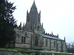 More images |
| Haughmond Abbey | Uffington | Abbey | 1130 | 17 February 1985 | SJ5417915119 52°43′54″N 2°40′48″W / 52.731756°N 2.679995°W / 52.731756; -2.679995 (Haughmond Abbey) | 1052157 |  More images |
| Former Church of St Michael | Upton Cressett | Church | Medieval | 9 March 1970 | SO6559892456 52°31′44″N 2°30′31″W / 52.52888°N 2.508533°W / 52.52888; -2.508533 (Former Church of St Michael) | 1367566 |  More images |
| Gatehouse at Upton Cressett Hall | Upton Cressett | Gatehouse | Elizabethan | 29 November 1951 | SO6558592407 52°31′41″N 2°30′31″W / 52.528089°N 2.508509°W / 52.528089; -2.508509 (Gatehouse at Upton Cressett Hall) | 1053757 |  |
| Upton Cressett Hall | Upton Cressett | Aisled Hall House | Medieval | 29 November 1951 | SO6558492402 52°31′42″N 2°30′31″W / 52.528438°N 2.508719°W / 52.528438; -2.508719 (Upton Cressett Hall) | 1190045 |  More images |
| Church of St Mary | Edstaston, Wem Rural | Chapel of Ease | Late 12th century | 28 October 1960 | SJ5177031975 52°52′59″N 2°43′05″W / 52.883061°N 2.71816°W / 52.883061; -2.71816 (Church of St Mary) | 1236691 |  More images |
| The Obelisk, Hawkstone Park | Hawkstone Park, Weston-under-Redcastle | Column | 1795 | 28 October 1960 | SJ5790429222 52°51′32″N 2°37′36″W / 52.858831°N 2.626656°W / 52.858831; -2.626656 (The Obelisk, Hawkstone Park) | 1264272 |  More images |
| Church of Saint Alkmund | Whitchurch | Church | 1089 | 1 May 1951 | SJ5409641713 52°58′15″N 2°41′06″W / 52.970796°N 2.684978°W / 52.970796; -2.684978 (Church of Saint Alkmund) | 1177510 |  More images |
| Domestic Chapel Approximately 350 Metres South of Halston Hall | Whittington | Domestic Chapel | Early 16th century | 8 October 1959 | SJ3388331297 52°52′30″N 2°59′02″W / 52.875062°N 2.983793°W / 52.875062; -2.983793 (Domestic Chapel Approximately 350 Metres South of Halston Hall) | 1367397 | Upload Photo |
| Halston Hall including attached Flanking Walls and Balustrade to Rear | Whittington | Country House | c. 1690 | 19 January 1952 | SJ3392631653 52°52′42″N 2°59′00″W / 52.878267°N 2.983226°W / 52.878267; -2.983226 (Halston Hall including attached Flanking Walls and Balustrade to Rear) | 1054216 |  More images |
| Whittington Castle | Whittington | Castle | Late 11th century or 12th century | 8 October 1959 | SJ3261531148 52°52′25″N 3°00′09″W / 52.873565°N 3.002598°W / 52.873565; -3.002598 (Whittington Castle) | 1178307 |  More images |
| Whitton Court | Whitton | Courtyard House | 19th century | 12 November 1954 | SO5788373470 52°21′28″N 2°37′11″W / 52.357662°N 2.619848°W / 52.357662; -2.619848 (Whitton Court) | 1383591 | Upload Photo |
| Davenport House | Worfield | Country House | 1726 | 29 November 1951 | SO7535795437 52°33′22″N 2°21′54″W / 52.556209°N 2.364907°W / 52.556209; -2.364907 (Davenport House) | 1053732 |  More images |
| Church of All Saints | Worthen, Worthen with Shelve | Parish Church | Late 12th century | 21 March 1968 | SJ3283504682 52°38′09″N 2°59′38″W / 52.635712°N 2.993899°W / 52.635712; -2.993899 (Church of All Saints) | 1055014 |  More images |
| Church of St Andrew | Wroxeter, Wroxeter and Uppington | Cross | 17th century | 13 June 1958 | SJ5633008247 52°40′13″N 2°38′50″W / 52.670162°N 2.647229°W / 52.670162; -2.647229 (Church of St Andrew) | 1224008 |  More images |
Telford and Wrekin
| Name | Location | Type | Completed [note 1] | Date designated | Grid ref.[note 2] Geo-coordinates | Entry number [note 3] | Image |
|---|---|---|---|---|---|---|---|
| Church of St Peter | Edgmond | Sundial | 18th century | 18 June 1959 | SJ7202719288 52°46′14″N 2°24′58″W / 52.770454°N 2.416054°W / 52.770454; -2.416054 (Church of St Peter) | 1054183 |  More images |
| Church of St Michael and Remains of Churchyard Cross | High Ercall, Ercall Magna | Church & Cross | Early Medieval | 18 June 1959 | SJ5946417351 52°45′08″N 2°36′07″W / 52.752243°N 2.602012°W / 52.752243; -2.602012 (Church of St Michael and Remains of Churchyard Cross) | 1038604 |  More images |
| Remains of Lilleshall Abbey | Lilleshall, Lilleshall and Donnington | Abbey | 12th century | 18 June 1959 | SJ7376514208 52°43′30″N 2°23′24″W / 52.724876°N 2.389886°W / 52.724876; -2.389886 (Remains of Lilleshall Abbey) | 1293216 | 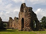 More images |
| Abbey Wall South East of Lilleshall Abbey | Lilleshall, Lilleshall and Donnington | Abbey | Medieval | 8 April 1983 | SJ7386114037 52°43′24″N 2°23′18″W / 52.723344°N 2.388451°W / 52.723344; -2.388451 (Abbey Wall South East of Lilleshall Abbey) | 1038252 | Upload Photo |
| Church of St Michael and All Angels | Lilleshall, Lilleshall and Donnington | Church | Late Norman | 18 June 1959 | SJ7286715285 52°44′04″N 2°24′12″W / 52.734513°N 2.403271°W / 52.734513; -2.403271 (Church of St Michael and All Angels) | 1038247 |  More images |
| Gatehouse South West of Madeley Court | Madeley | Gatehouse | Late 16th century or Early 17th century | 8 April 1983 | SJ6953405113 52°38′34″N 2°27′06″W / 52.642895°N 2.451685°W / 52.642895; -2.451685 (Gatehouse South West of Madeley Court) | 1292950 | 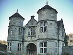 More images |
| Preston Hospital including Screen and Gates in front | Preston upon the Weald Moors | Hospital & Gates | 18th century | 4 January 1952 | SJ6790015326 52°44′05″N 2°28′37″W / 52.734609°N 2.476832°W / 52.734609; -2.476832 (Preston Hospital including Screen and Gates in front) | 1292617 |  More images |
| Longdon Aqueduct (aqueduct on the Shrewsbury Canal) | Shrewsbury Canal, Rodington | Aqueduct | Pre 1795 | 30 March 1971 | SJ6175515640 52°44′13″N 2°34′04″W / 52.73703°N 2.567871°W / 52.73703; -2.567871 (Longdon Aqueduct (aqueduct on the Shrewsbury Canal)) | 1037006 |  More images |
| Church of St James | Stirchley, Stirchley and Brookside | Church | 12th century | 8 April 1983 | SJ6998306720 52°39′27″N 2°26′43″W / 52.657366°N 2.445197°W / 52.657366; -2.445197 (Church of St James) | 1352002 | 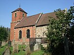 More images |
| The Iron Bridge | Ironbridge, The Gorge | Footbridge | 1779 | 8 April 1983 | SJ6723803396 52°37′38″N 2°29′08″W / 52.627326°N 2.485445°W / 52.627326; -2.485445 (The Iron Bridge) | 1038659 |  More images |
| The Old Furnace at Coalbrookdale Ironworks | Coalbrookdale, The Gorge | Blast Furnace | 1638 | 8 April 1983 | SJ6675504879 52°38′26″N 2°29′34″W / 52.640628°N 2.49273°W / 52.640628; -2.49273 (The Old Furnace at Coalbrookdale Ironworks) | 1054135 |  More images |
| Church of St Peter | Wrockwardine | Church | 12th century | 18 June 1959 | SJ6245812051 52°42′17″N 2°33′25″W / 52.704818°N 2.557048°W / 52.704818; -2.557048 (Church of St Peter) | 1030939 |  More images |
See also
- Grade I listed churches in Shropshire
- Category:Grade I listed buildings in Shropshire
Notes
- ^ a b The date given is the date used by Historic England as significant for the initial building or that of an important part in the structure's description.
- ^ a b Sometimes known as OSGB36, the grid reference is based on the British national grid reference system used by the Ordnance Survey.
- ^ a b The "List Entry Number" is a unique number assigned to each listed building and scheduled monument by Historic England.
References
National Heritage List for England
External links
![]() Media related to Grade I listed buildings in Shropshire at Wikimedia Commons
Media related to Grade I listed buildings in Shropshire at Wikimedia Commons
- v
- t
- e
- Bedfordshire
- Berkshire
- Bristol
- Buckinghamshire
- Cambridgeshire
- Cheshire
- Cornwall
- Cumbria
- Derbyshire
- Devon
- Dorset
- Durham
- East Sussex
- East Riding of Yorkshire
- Essex
- Gloucestershire
- Greater London
- Greater Manchester
- Hampshire
- Herefordshire
- Hertfordshire
- Isle of Wight
- Kent
- Lancashire
- Leicestershire
- Lincolnshire
- Merseyside
- Norfolk
- North Yorkshire
- Northamptonshire
- Northumberland
- Nottinghamshire
- Oxfordshire
- Rutland
- Shropshire
- Somerset
- South Yorkshire
- Staffordshire
- Suffolk
- Surrey
- Tyne and Wear
- Warwickshire
- West Midlands
- West Sussex
- West Yorkshire
- Wiltshire
- Worcestershire
- Babergh
- Bath and North East Somerset
- Bradford
- Brighton and Hove
- Broadland
- Cheltenham
- Cheshire East
- Cheshire West and Chester
- Cotswold
- Craven
- Dartford
- Dover
- Forest Heath
- Forest of Dean
- Ipswich
- Maidstone
- Mendip
- Mid Suffolk
- North Somerset
- Sedgemoor
- South Gloucestershire
- South Somerset
- St Edmundsbury
- Stroud
- Suffolk Coastal
- Taunton Deane
- Tewkesbury
- Waveney
- West Somerset
- Churches
- War memorials
- 20th century


