Gardanne
Commune in Provence-Alpes-Côte d'Azur, France
You can help expand this article with text translated from the corresponding article in French. (December 2008) Click [show] for important translation instructions.
- View a machine-translated version of the French article.
- Machine translation, like DeepL or Google Translate, is a useful starting point for translations, but translators must revise errors as necessary and confirm that the translation is accurate, rather than simply copy-pasting machine-translated text into the English Wikipedia.
- Do not translate text that appears unreliable or low-quality. If possible, verify the text with references provided in the foreign-language article.
- You must provide copyright attribution in the edit summary accompanying your translation by providing an interlanguage link to the source of your translation. A model attribution edit summary is
Content in this edit is translated from the existing French Wikipedia article at [[:fr:Gardanne]]; see its history for attribution. - You may also add the template
{{Translated|fr|Gardanne}}to the talk page. - For more guidance, see Wikipedia:Translation.
Commune in Provence-Alpes-Côte d'Azur, France

Coat of arms
Location of Gardanne

(2020–2026) Hervé Granier[1]
1
(2021)[2]
13041 /13120
(avg. 205 m or 673 ft)
Gardanne (French pronunciation: [ɡaʁdan]; Occitan: Gardana) is a commune in the Bouches-du-Rhône department in southern France. Its inhabitants are called Gardannais.
Geography
It is close to Aix-en-Provence and Marseille and on the rail link connecting the two cities.
It is bordered by the Massif du Montaiguet, which expands to Luynes, Aix en Provence and Bouc-Bel-Air. It comprises chalky plateaux bordered by cliffs, forests of pines and oaks, and crops areas. In 1979 and 2005 the area was devastated by bush fires. Following these incidents, garrigue is now covering a wide area.
History
Walls dating back to the first century AD have been found.[3]
In 1454 René d'Anjou bought the estate and would go there until 1480.[3] In 1482 it was bought back by the Forbins[3] and in 1676 the villagers themselves bought back their own land.[3]
In the 1860s a railway was built[3] and a little later mines were dug, thus attracting Italian, Armenian, Polish, Czech, Spanish and African workers to the village.[3] The deep mine, one of the last surviving in France, was closed down in 2003.[3]
Energy
The Centrale thermique de Provence, a thermal power station is located in Gardanne. It runs on coal and biomass and uses the technology known as the circulating fluidized bed.[4] It has the highest chimney in France which rises to 297 m. In 2018, the site director presented it as the third tallest building in France, after the Eiffel Tower and the Millau viaduct.[5] The plant will be closed before 2022 in order to reduce greenhouse gas (CO2) emissions in accordance with the PPE law.[6]
 |
Population
|
| ||||||||||||||||||||||||||||||||||||||||||||||||||||||||||||||||||||||||||||||||||||||||||||||||||||||||||||||||||
| |||||||||||||||||||||||||||||||||||||||||||||||||||||||||||||||||||||||||||||||||||||||||||||||||||||||||||||||||||
| Source: EHESS[7] and INSEE (1968-2017)[8] | |||||||||||||||||||||||||||||||||||||||||||||||||||||||||||||||||||||||||||||||||||||||||||||||||||||||||||||||||||
Politics
The commune of Gardanne was governed by the French Communist Party under Mayor Roger Meï from 1977 until 2020. Voting is usually towards the left-wing, but rather uncharacteristically, Nicolas Sarkozy gained 53.1% of the vote at the second round of the 2007 French presidential election.[citation needed]
| Term | Name | Party |
|---|---|---|
| 1977–2020 | Roger Meï | PCF |
| 2020–incumbent | Herve Granier | LR |
Picture gallery
-
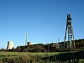 Centrale Thermique de Provence and the preserved Puits Z
 -
 Puits Yvon-Morandat
 -
 Cooling tower of the coal-fired Centrale Thermique de Provence


See also
References
- ^ "Répertoire national des élus: les maires" (in French). data.gouv.fr, Plateforme ouverte des données publiques françaises. 4 May 2022.
- ^ "Populations légales 2021". The National Institute of Statistics and Economic Studies. 28 December 2023.
- ^ a b c d e f g :: Ville de Gardanne ::
- ^ "Charbon propre : la centrale thermique de Gardanne". www.lakko.fr. Retrieved 19 April 2020.
- ^ "La centrale biomasse de Gardanne effraie le Var". Var-Matin (in French). 25 February 2016. Retrieved 19 April 2020.
- ^ "Gardanne : le gouvernement confirme la fermeture de la centrale à charbon en 2022". France 3 Provence-Alpes-Côte d'Azur (in French). Retrieved 19 April 2020.
- ^ Des villages de Cassini aux communes d'aujourd'hui: Commune data sheet Gardanne, EHESS (in French).
- ^ Population en historique depuis 1968, INSEE
External links
Wikimedia Commons has media related to Gardanne.
- Official website (in French)
- v
- t
- e

- Aix-en-Provencesubpr
- Allauch
- Alleins
- Arlessubpr
- Aubagne
- Aureille
- Auriol
- Aurons
- La Barben
- Barbentane
- Les Baux-de-Provence
- Beaurecueil
- Belcodène
- Berre-l'Étang
- Bouc-Bel-Air
- La Bouilladisse
- Boulbon
- Cabannes
- Cabriès
- Cadolive
- Carnoux-en-Provence
- Carry-le-Rouet
- Cassis
- Ceyreste
- Charleval
- Châteauneuf-le-Rouge
- Châteauneuf-les-Martigues
- Châteaurenard
- La Ciotat
- Cornillon-Confoux
- Coudoux
- Cuges-les-Pins
- La Destrousse
- Éguilles
- Ensuès-la-Redonne
- Eygalières
- Eyguières
- Eyragues
- La Fare-les-Oliviers
- Fontvieille
- Fos-sur-Mer
- Fuveau
- Gardanne
- Gémenos
- Gignac-la-Nerthe
- Grans
- Graveson
- Gréasque
- Istressubpr
- Jouques
- Lamanon
- Lambesc
- Lançon-Provence
- Maillane
- Mallemort
- Marignane
- Marseillepref
- Martigues
- Mas-Blanc-des-Alpilles
- Maussane-les-Alpilles
- Meyrargues
- Meyreuil
- Mimet
- Miramas
- Mollégès
- Mouriès
- Noves
- Orgon
- Paradou
- Pélissanne
- Les Pennes-Mirabeau
- La Penne-sur-Huveaune
- Peynier
- Peypin
- Peyrolles-en-Provence
- Plan-de-Cuques
- Plan-d'Orgon
- Port-de-Bouc
- Port-Saint-Louis-du-Rhône
- Puyloubier
- Le Puy-Sainte-Réparade
- Rognac
- Rognes
- Rognonas
- La Roque-d'Anthéron
- Roquefort-la-Bédoule
- Roquevaire
- Rousset
- Le Rove
- Saint-Andiol
- Saint-Antonin-sur-Bayon
- Saint-Cannat
- Saint-Chamas
- Saintes-Maries-de-la-Mer
- Saint-Estève-Janson
- Saint-Étienne-du-Grès
- Saint-Marc-Jaumegarde
- Saint-Martin-de-Crau
- Saint-Mitre-les-Remparts
- Saint-Paul-lès-Durance
- Saint-Pierre-de-Mézoargues
- Saint-Rémy-de-Provence
- Saint-Savournin
- Saint-Victoret
- Salon-de-Provence
- Sausset-les-Pins
- Sénas
- Septèmes-les-Vallons
- Simiane-Collongue
- Tarascon
- Le Tholonet
- Trets
- Vauvenargues
- Velaux
- Venelles
- Ventabren
- Vernègues
- Verquières
- Vitrolles
- pref: prefecture
- subpr: subprefecture
Authority control databases | |
|---|---|
| International |
|
| National |
|
| Geographic |
|
| Other |
|
 | This Bouches-du-Rhône geographical article is a stub. You can help Wikipedia by expanding it. |
- v
- t
- e


