Cumnock, North Carolina
Unincorporated community in North Carolina, United States
35°33′18″N 79°14′16″W / 35.55500°N 79.23778°W / 35.55500; -79.2377827237[2]
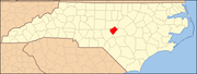
Cumnock, formerly known as Egypt,[3] is an unincorporated community in northwestern Lee County, North Carolina, United States. It lies on Cumnock Road, about a mile north of U.S. Route 421.
Endor Iron Furnace is located near the community. It was listed on the National Register of Historic Places in 1974.[4] The Deep River Camelback Truss Bridge was listed in 1995.[4]
History
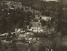
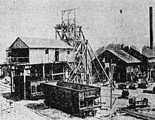
Egypt (now Cumnock) was the site of the Egypt Coal Mine which operated between 1855 and 1928.[3]
References
- ^ a b U.S. Geological Survey Geographic Names Information System: Cumnock, North Carolina
- ^ "Cumnock ZIP Code". zipdatamaps.com. 2022. Retrieved November 30, 2022.
- ^ a b Powell, William (1968). The North Carolina Gazetteer. Chapel Hill, North Carolina: University of North Carolina Press. p. 130.
- ^ a b "National Register Information System". National Register of Historic Places. National Park Service. July 9, 2010.
External links
- Atlantic & Yadkin Railway
- Margaret Wicker: The Coal Glen Mine Disaster (Mentions Egypt mine and Coal Glen mine)
- North Carolina Highway Historical Marker H-41 Egypt Coal Mine
- Escape NC Cumnock,NC
- Coal Deposits in the Deep River Field, Chatham, Lee, and Moore Counties, N.C.
- v
- t
- e
Municipalities and communities of Lee County, North Carolina, United States
County seat: Sanford
communities
- Colon
- Cumnock
- Lemon Springs
- Tramway
‡This populated place also has portions in an adjacent county or counties
- North Carolina portal
- United States portal
This article about a location in Lee County, North Carolina is a stub. You can help Wikipedia by expanding it. |
- v
- t
- e


