Csenger District
Districts of Hungary in Szabolcs-Szatmár-Bereg
Csenger District Csengeri járás | |
|---|---|
Districts of Hungary | |
 Coat of arms | |
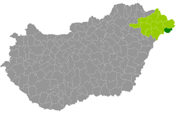 Csenger District within Hungary and Szabolcs-Szatmár-Bereg County. | |
| Country |  Hungary Hungary |
| County | Szabolcs-Szatmár-Bereg |
| District seat | Csenger |
| Area | |
| • Total | 246.51 km2 (95.18 sq mi) |
| • Rank | 11th in Szabolcs-Szatmár-Bereg |
| Population (2011 census) | |
| • Total | 13,485 |
| • Rank | 13th in Szabolcs-Szatmár-Bereg |
| • Density | 55/km2 (140/sq mi) |
Csenger (Hungarian: Csengeri járás) is a district in eastern part of Szabolcs-Szatmár-Bereg County. Csenger is also the name of the town where the district seat is found. The district is located in the Northern Great Plain Statistical Region. This district is a part of Szatmár historical and geographical region.
Geography
Csenger District borders with Fehérgyarmat District to the north, the Romanian county of Satu Mare to the east and south, and with Mátészalka District to the west. The number of the inhabited places in Csenger District is 11.
Municipalities
The district has 1 town, 2 large villages and 8 villages (ordered by population, as of 1 January 2013):[1]
- Csenger (4,924) – district seat
- Csengersima (779)
- Csengerújfalu (819)
- Komlódtótfalu (122)
- Pátyod (675)
- Porcsalma (2,682)
- Szamosangyalos (477)
- Szamosbecs (374)
- Szamostatárfalva (308)
- Tyukod (2,041)
- Ura (638)
The bolded municipality is a city, municipalities in italics are large villages.
Demographics
Religion in Csenger District (2011 census)
Calvinism (61.1%)
Greek Catholicism (13.2%)
Catholic Church (8.1%)
Orthodoxy (0.4%)
Other religions (1.4%)
Non-religious (3.2%)
Atheists (0.1%)
Undeclared (12.5%)
In 2011, it had a population of 13,485 and the population density was 55/km2.
| Year | County population[2] | Change |
|---|---|---|
| 2011 | 13,485 | n/a |
Ethnicity
Besides the Hungarian majority, the main minorities are the Roma (approx. 2,500) and Romanians (200).
Total population (2011 census): 13,485
Ethnic groups (2011 census):[3] Identified themselves: 14,221 persons:
- Hungarians: 12,262 (86.22%)
- Gypsies: 1,704 (11.98%)
- Romanians: 178 (1.25%)
- Others and indefinable: 77 (0.54%)
Approx. 1,000 persons in Csenger District did declare more than one ethnic group at the 2011 census.
Religion
Religious adherence in the county according to 2011 census:[4]
- Reformed – 8,244;
- Catholic – 2,872 (Greek Catholic – 1,783; Roman Catholic – 1,089);
- Orthodox – 55;
- other religions – 181;
- Non-religious – 434;
- Atheism – 11;
- Undeclared – 1,688.
Gallery
-
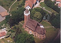 Csenger, the district seat
 -
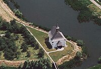 Aerial view of Csengersima
 -
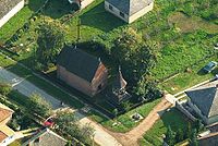 Aerial view of Szamostatárfalva
 -
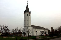 Reformed Church in Porcsalma


See also
References
External links
- Postal codes of the Csenger District

47°50′00″N 22°37′00″E / 47.8333°N 22.6167°E / 47.8333; 22.6167
 | This Szabolcs-Szatmár-Bereg location article is a stub. You can help Wikipedia by expanding it. |
- v
- t
- e


