Cahan, Orne
Commune in Normandy, France
Location of Cahan

(2020–2026) Xavier De Saint Pol[1]
1
(2021)[2]
61069 /61430
(avg. 140 m or 460 ft)
Cahan is a commune in the Orne department in north-western France.
Geography
The commune is part of the area known as Suisse Normande.[3]
The commune is made up of the following collection of villages and hamlets, Fourneaux,La Bijude, Le Haut Vardon, Le Bas Vardon and Cahan.[4]
The commune has 2 watercourses running through it the river Noireau and 1 stream the Mare des Bois.
Neighbouring communes[4] | ||||||||||||||||
|---|---|---|---|---|---|---|---|---|---|---|---|---|---|---|---|---|
| ||||||||||||||||


Population
| Year | Pop. | ±% p.a. |
|---|---|---|
| 1968 | 250 | — |
| 1975 | 205 | −2.80% |
| 1982 | 223 | +1.21% |
| 1990 | 211 | −0.69% |
| 1999 | 187 | −1.33% |
| 2007 | 203 | +1.03% |
| 2012 | 155 | −5.25% |
| 2017 | 181 | +3.15% |
| Source: INSEE[5] | ||
-
 La mairie de Cahan
 -
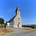 Church of Saint-Pierre in Cahan
 -
 Cahan village


See also
References
- ^ "Répertoire national des élus: les maires". data.gouv.fr, Plateforme ouverte des données publiques françaises (in French). 9 August 2021.
- ^ "Populations légales 2021". The National Institute of Statistics and Economic Studies. 28 December 2023.
- ^ "Map of Suiss Normande" (PDF).
- ^ a b "Google Maps". Google Maps.
- ^ Population en historique depuis 1968, INSEE
Wikimedia Commons has media related to Cahan.
- v
- t
- e
 Communes of the Orne department
- L'Aigle
- Alençonpref
- Almenêches
- Appenai-sous-Bellême
- Argentansubpr
- Les Aspres
- Athis-Val de Rouvre
- Aube
- Aubry-le-Panthou
- Aubusson
- Auguaise
- Aunay-les-Bois
- Aunou-le-Faucon
- Aunou-sur-Orne
- Les Authieux-du-Puits
- Avernes-Saint-Gourgon
- Avoine
- Avrilly
- Bagnoles de l'Orne Normandie
- Bailleul
- Banvou
- Barville
- Bazoches-au-Houlme
- Bazoches-sur-Hoëne
- La Bazoque
- Beaufai
- Beaulieu
- Beauvain
- Belfonds
- Belforêt-en-Perche
- Bellavilliers
- Bellême
- La Bellière
- Bellou-en-Houlme
- Bellou-le-Trichard
- Berd'huis
- Berjou
- Bizou
- Boëcé
- Boischampré
- Boissei-la-Lande
- Boitron
- Bonnefoi
- Bonsmoulins
- Le Bosc-Renoult
- Boucé
- Le Bouillon
- Brethel
- Bretoncelles
- Brieux
- Briouze
- Brullemail
- Buré
- Bures
- Bursard
- Cahan
- Caligny
- Camembert
- Canapville
- Carrouges
- Ceaucé
- Le Cercueil
- Cerisé
- Cerisy-Belle-Étoile
- Ceton
- Chahains
- Chailloué
- Le Chalange
- Champcerie
- Le Champ-de-la-Pierre
- Les Champeaux
- Champeaux-sur-Sarthe
- Champ-Haut
- Champosoult
- Champsecret
- Chandai
- Chanu
- La Chapelle-au-Moine
- La Chapelle-Biche
- La Chapelle-Montligeon
- La Chapelle-près-Sées
- La Chapelle-Souëf
- La Chapelle-Viel
- Charencey
- Le Château-d'Almenêches
- Le Châtellier
- Chaumont
- La Chaux
- Chemilli
- Ciral
- Cisai-Saint-Aubin
- Colombiers
- Comblot
- Commeaux
- Condé-sur-Sarthe
- Corbon
- Coudehard
- Coulimer
- Coulmer
- Coulonces
- La Coulonche
- Coulonges-sur-Sarthe
- Courgeon
- Courgeoût
- Cour-Maugis sur Huisne
- Courtomer
- Craménil
- Croisilles
- Crouttes
- Crulai
- Cuissai
- Dame-Marie
- Damigny
- Domfront en Poiraie
- Dompierre
- Durcet
- Échalou
- Échauffour
- Écorcei
- Écorches
- Écouché-les-Vallées
- Écouves
- Essay
- Faverolles
- Fay
- Feings
- La Ferrière-au-Doyen
- La Ferrière-aux-Étangs
- La Ferrière-Béchet
- La Ferrière-Bochard
- Ferrières-la-Verrerie
- La Ferté-en-Ouche
- La Ferté-Macé
- Flers
- Fleuré
- Fontaine-les-Bassets
- Francheville
- La Fresnaie-Fayel
- Fresnay-le-Samson
- Gacé
- Gandelain
- Gâprée
- Les Genettes
- La Genevraie
- Giel-Courteilles
- Ginai
- Godisson
- La Gonfrière
- Gouffern en Auge
- Le Grais
- Guêprei
- Guerquesalles
- Habloville
- Hauterive
- Héloup
- L'Hôme-Chamondot
- Igé
- Irai
- Joué-du-Bois
- Joué-du-Plain
- Juvigny-sur-Orne
- Juvigny Val d'Andaine
- Lalacelle
- Laleu
- La Lande-de-Goult
- La Lande-de-Lougé
- La Lande-Patry
- La Lande-Saint-Siméon
- Landigou
- Landisacq
- Larré
- Lignères
- Lignou
- Loisail
- Longny les Villages
- Lonlay-l'Abbaye
- Lonlay-le-Tesson
- Lonrai
- Lougé-sur-Maire
- Louvières-en-Auge
- Macé
- La Madeleine-Bouvet
- Le Mage
- Magny-le-Désert
- Mahéru
- Mantilly
- Marchemaisons
- Mardilly
- Mauves-sur-Huisne
- Médavy
- Méhoudin
- Le Mêle-sur-Sarthe
- Le Ménil-Bérard
- Le Ménil-Broût
- Le Ménil-Ciboult
- Le Ménil-de-Briouze
- Ménil-Erreux
- Ménil-Froger
- Ménil-Gondouin
- Le Ménil-Guyon
- Ménil-Hermei
- Ménil-Hubert-en-Exmes
- Ménil-Hubert-sur-Orne
- Le Ménil-Scelleur
- Le Ménil-Vicomte
- Ménil-Vin
- Les Menus
- Le Merlerault
- Merri
- La Mesnière
- Messei
- Mieuxcé
- Moncy
- Montabard
- Montchevrel
- Montgaudry
- Montilly-sur-Noireau
- Montmerrei
- Mont-Ormel
- Montreuil-au-Houlme
- Montreuil-la-Cambe
- Les Monts d'Andaine
- Montsecret-Clairefougère
- Monts-sur-Orne
- Mortagne-au-Perchesubpr
- Mortrée
- La Motte-Fouquet
- Moulins-la-Marche
- Moulins-sur-Orne
- Moutiers-au-Perche
- Neauphe-sous-Essai
- Neauphe-sur-Dive
- Nécy
- Neuilly-le-Bisson
- Neuville-sur-Touques
- Neuvy-au-Houlme
- Nonant-le-Pin
- Occagnes
- Ommoy
- L'Orée-d'Écouves
- Orgères
- Origny-le-Roux
- Pacé
- Parfondeval
- Le Pas-Saint-l'Homer
- Passais Villages
- Perche en Nocé
- Perrou
- Pervenchères
- Le Pin-au-Haras
- Le Pin-la-Garenne
- Planches
- Le Plantis
- Pointel
- Pontchardon
- Pouvrai
- Putanges-le-Lac
- Rai
- Rânes
- Rémalard en Perche
- Le Renouard
- Résenlieu
- Réveillon
- Ri
- Rives d'Andaine
- La Roche-Mabile
- Roiville
- Rônai
- Rouperroux
- Sablons-sur-Huisne
- Sai
- Saint-Agnan-sur-Sarthe
- Saint-André-de-Briouze
- Saint-André-de-Messei
- Saint-Aquilin-de-Corbion
- Saint-Aubin-d'Appenai
- Saint-Aubin-de-Bonneval
- Saint-Aubin-de-Courteraie
- Saint-Bômer-les-Forges
- Saint-Brice
- Saint-Brice-sous-Rânes
- Saint-Céneri-le-Gérei
- Saint-Christophe-de-Chaulieu
- Saint-Clair-de-Halouze
- Saint-Cyr-la-Rosière
- Saint-Denis-sur-Huisne
- Saint-Denis-sur-Sarthon
- Sainte-Céronne-lès-Mortagne
- Sainte-Gauburge-Sainte-Colombe
- Sainte-Honorine-la-Chardonne
- Sainte-Honorine-la-Guillaume
- Saint-Ellier-les-Bois
- Sainte-Marguerite-de-Carrouges
- Sainte-Marie-la-Robert
- Sainte-Opportune
- Sainte-Scolasse-sur-Sarthe
- Saint-Evroult-de-Montfort
- Saint-Evroult-Notre-Dame-du-Bois
- Saint-Fraimbault
- Saint-Fulgent-des-Ormes
- Saint-Georges-d'Annebecq
- Saint-Georges-des-Groseillers
- Saint-Germain-d'Aunay
- Saint-Germain-de-Clairefeuille
- Saint-Germain-de-la-Coudre
- Saint-Germain-de-Martigny
- Saint-Germain-des-Grois
- Saint-Germain-du-Corbéis
- Saint-Germain-le-Vieux
- Saint-Gervais-des-Sablons
- Saint-Gervais-du-Perron
- Saint-Gilles-des-Marais
- Saint-Hilaire-de-Briouze
- Saint-Hilaire-le-Châtel
- Saint-Hilaire-sur-Erre
- Saint-Hilaire-sur-Risle
- Saint-Jouin-de-Blavou
- Saint-Julien-sur-Sarthe
- Saint-Lambert-sur-Dive
- Saint-Langis-lès-Mortagne
- Saint-Léger-sur-Sarthe
- Saint-Léonard-des-Parcs
- Saint-Mard-de-Réno
- Saint-Mars-d'Égrenne
- Saint-Martin-d'Écublei
- Saint-Martin-des-Landes
- Saint-Martin-des-Pézerits
- Saint-Martin-du-Vieux-Bellême
- Saint-Martin-l'Aiguillon
- Saint-Michel-Tubœuf
- Saint-Nicolas-des-Bois
- Saint-Nicolas-de-Sommaire
- Saint-Ouen-de-Sécherouvre
- Saint-Ouen-le-Brisoult
- Saint-Ouen-sur-Iton
- Saint-Patrice-du-Désert
- Saint-Paul
- Saint-Philbert-sur-Orne
- Saint-Pierre-d'Entremont
- Saint-Pierre-des-Loges
- Saint-Pierre-du-Regard
- Saint-Pierre-la-Bruyère
- Saint-Quentin-de-Blavou
- Saint-Quentin-les-Chardonnets
- Saint-Roch-sur-Égrenne
- Saint-Sauveur-de-Carrouges
- Saint-Sulpice-sur-Risle
- Saint-Symphorien-des-Bruyères
- Saires-la-Verrerie
- Le Sap-André
- Sap-en-Auge
- Sarceaux
- Sées
- La Selle-la-Forge
- Semallé
- Sévigny
- Sevrai
- Soligny-la-Trappe
- Suré
- Tanques
- Tanville
- Tellières-le-Plessis
- Tessé-Froulay
- Ticheville
- Tinchebray-Bocage
- Torchamp
- Touquettes
- Tournai-sur-Dive
- Tourouvre au Perche
- Trémont
- La Trinité-des-Laitiers
- Trun
- Val-au-Perche
- Valframbert
- Vaunoise
- Les Ventes-de-Bourse
- La Ventrouze
- Verrières
- Vidai
- Vieux-Pont
- Villedieu-lès-Bailleul
- Villiers-sous-Mortagne
- Vimoutiers
- Vitrai-sous-Laigle
- Les Yveteaux
- pref: prefecture
- subpr: subprefecture
| Authority control databases: National |
|
|---|
 | This Orne geographical article is a stub. You can help Wikipedia by expanding it. |
- v
- t
- e


