Basufan (Arabic: باصوفان; Kurdish: Basûfan)[2] (sometimes spelled Bassoûfâne, Bassoufane, Bosoufane, Bāşūfān) is an ancient village located in northwestern Syria. The village is populated by Yezidi Kurds and had a population of 901 in the 2004 census according to the Syria Central Bureau of Statistics (CBS),[1][2] and had a population of 2059 according to the civil registry records at the end of 2005.[2]
The village is notable for being the site of a former fifth-century church dedicated to Saint Phocas.
Location
The village of Basufan is located in Aleppo Governorate, about 30 kilometers northwest of the city of Aleppo. It is built at an altitude of 632 meters,[3] and is located to the east of Mount Simeon.
Description
The village hosts several vestiges of the Byzantine-era settlement which are dated between the fifth and the seventh centuries. Howard Crosby Butler, in 1905, at the head of an archaeological expedition from the American University of Princeton, mentioned a large Islamic cemetery located around the ancient church. He also mentioned having found the remains of another church, older and completely destroyed.[4] The church dedicated to Saint Phocas was probably part of a monastic complex. The same year, Gertrude Bell crossed Basufan and found the village mainly inhabited by Kurds, who rented their houses during the hot summer months to Christians and Jews of Aleppo who had come on vacation.[5]
Church of St. Phocas
South façade of the Church of Saint Phocas. Photo by Frank Kidner.
St. Phocas Church, now in ruins, was a basilica with three naves separated by columns. According to an inscription on the south wall, the building was dedicated to Saint Phocas and erected in 491-492.
The nave was 24 meters long and 15.4 wide. The arches of the nave rested on columns, while the outer walls were reinforced by pilasters. To the east, the chevet was composed of two rectangular apses framing a semicircular central apse. The two rectangular apses connected to the lateral aisles, and the south room was also open to the central apse, serving as a martyrium. The building bore a resemblance to the church of Qal'at Sem'an[6] which could result from an imitation of the architecture of the latter.[7] Access to the nave was through a door in the middle of the south façade, and a second access was on the west gable.[8]
Photographs by Gertrude Bell
Kurdish girl standing in doorway.
Kurdish man in front of the church apse. Twisted column, Corinthian capital.
^Howard Crosby Butler: Syria. Publications of the Princeton University Archaeological Expeditions to Syria in 1904–5 and 1909. Division I: Geography and Itinerary. E. J. Brill, Leiden 1930, p. 73, En ligne sur Archive.org
^Gertrude Bell, Am Ende des Lavastromes. Durch die Wüsten und Kulturstätten Syriens. Gabriele Habinger (Hrsg.), Promedia, Wien 1991, p. 254. Édition originale : The Desert and the Sown, 1908
^Jean-Pierre Sodini, Jean-Luc Biscop, Qal'at Sem'an et les chevets à colonnes de Syrie du Nord, Syria, 1984, Volume 61, pp. 267-330, p.282, JSTOR
^Michel Kaplan, Le sacré et son inscription dans l'espace à Byzance et en Occident, Publications de la Sorbonne, 2001 - 318 pages, p.251 lire en ligne
^Howard Crosby Butler: Early Churches in Syria. Fourth to Seventh Centuries.Princeton University Press, Princeton 1929, p. 67, 69 (Plan), 70
 Syria
Syria
 Kurdish girl standing in doorway.
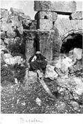 Kurdish man in front of the church apse. Twisted column, Corinthian capital.
 Inscription in Syriac.


